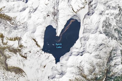


A picture of a heart-shaped lake definitely sounds like something that’s been photoshopped and does the rounds on Facebook every Valentine’s Day, but the lovely shape of Spirit Lake, Washington, is very much real.
The rest of this article is behind a paywall. Please sign in or subscribe to access the full content.However, it hasn’t always looked this way. Rather than the full heart that we can see in satellite imagery today, the lake used to be more like the top half of a heart, with east and west arms only narrowly connected.
It was also once a popular tourist destination, teeming with swimmers, sailors, and fishers who stayed in the cabins and lodges surrounding the lake.

That all changed with the deadly eruption of Mount St Helens, which sits to the southwest of the lake, on May 18, 1980. The eruption led to an increase in the surface elevation of the lake by nearly 60 meters (200 feet) and the resulting landslide of debris forced its waters out onto nearby land.
But gradually, water flowed back in on top of the debris, creating the broader, shallower, and very much heart-shaped lake that we know of today. As well as its changed anatomy, Spirit Lake is home to a mat of floating logs uprooted by the eruption, serving as a reminder of what happened nearly 45 years ago.

Long gone are the days when the lake’s waters would be full of tourists – access to the site is now limited, with fishing and swimming strictly prohibited, though there is a designated viewpoint that’s open when conditions allow.
Instead, Spirit Lake is being preserved as a natural laboratory for studying the recovery of landscapes after volcanic eruptions, with its undisturbed log mat of particular interest to researchers.
“More lakes would have log mats, but often logs are removed for recreation and timber harvest,” said environmental engineer Jim Gawel, who studies the lake, speaking to NASA’s Earth Observatory. “We would love to learn of other lakes in the world with large numbers of floating logs for comparison to Spirit Lake.”