

Antarctica is caked in a layer of ice with an average thickness of 2.2 kilometers (1.4 miles). Unlike the Arctic in the Northern Hemisphere, beneath this ice is a continental landmass featuring rocky mountains, volcanoes, and vast canyons that have been tombed for millions of years.
The rest of this article is behind a paywall. Please sign in or subscribe to access the full content.Thanks to decades worth of satellite data and radar surveys, it’s possible to see the "lumps and bumps" of the long-lost bedrock with unbelievable clarity.
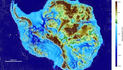
One of the most comprehensive maps of the world’s southernmost continental landmass is known as BedMachine Antarctica.
Published in 2019, the project was a huge operation involving 19 research institutes from around the world, including NASA, the National Science Foundation, the University of California Irvine, the Australian government’s Cooperative Research Centres Programme, the National Natural Science Foundation of China, the British Antarctic Survey, and many more.

The map is a fascinating sight; like using X-ray specs to peer inside an ice-covered continent. However, it also has scientific potential. Using data from the map, researchers can gain all kinds of insights into the geographical mysteries of Antarctica, from the continent’s topography to the future of its troubled ice sheets.
One of the biggest surprises from the map was the true scale of the canyon beneath the Denman Glacier. With a depth of 3,500 meters (11,500 feet) below sea level, the ice-filled Denman trough is the deepest point on continental Earth.
“Older maps suggested a shallower canyon, but that wasn’t possible; something was missing. With conservation of mass, by combining existing radar survey and ice motion data, we know how much ice flows through the canyon – which, by our calculations, reaches 3,500 meters below sea level, the deepest point on land. Since it’s relatively narrow, it has to be deep to allow that much ice mass to reach the coast,” Mathieu Morlighem, associate professor of Earth system science at the University of California, Irvine, said in a 2019 statement.
Over 97 percent of Antarctica is covered in ice, which has encased much of the continent for millions upon millions of years. At its thickest, the ice measures nearly 4.9 kilometers (3 miles) deep – the height of six Burj Khalifas stacked on top of each other.
However, ice is just one part of its extreme geography. One lesser-known feature of Antarctica is its volcanic tendencies. One study in 2017 identified 138 volcanoes in West Antarctica alone. While most of these are dormant, eight or nine of the Antarctic volcanoes are regarded as active. One of the most ferocious volcanoes on the continent is Mount Erebus, the tallest active volcano in Antarctica – with a summit elevation of 3,794 meters (12,448 feet) – and the southernmost active volcano on Earth.
It’s easy to imagine Antarctica as a frigid and, dare we say, boring ice cube at the bottom of our planet. Look closer, though, and you’ll see it's a dynamic and monumental world, filled with secrets and unexpected stories.