Nature
 PUBLISHED



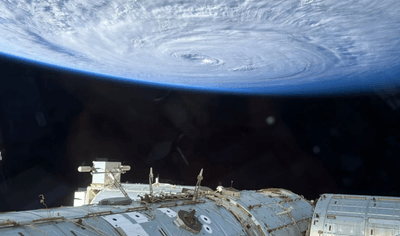


As a typhoon swirled violently in the Pacific Ocean, NASA astronaut Anil Menon and his smartphone had a front-row seat onboard the International Space Station (ISS), some 400 kilometers (250 miles) above the chaos below.
Menon shared the photo on his social media on August 2 2026, with the caption: “The Pacific Ocean this morning from the cupola with an iPhone.”
What typhoon is it?
He didn’t specify which tropical storm caught his eye, but Typhoon Dolphin fits the bill.
It reached category 5 strength on July 30 as it gusted through the northwest Pacific Ocean with wind speeds of up to 270 kilometers (165 miles) per hour.
Its aggression briefly earned it the title of a "super typhoon", although it has since been downgraded to the so-called Strong category.
As of August 7, it’s still causing a ruckus over the sea, passing between southwestern Japan and Taiwan on Friday morning. It will continue heading east before making landfall along China's eastern coast, between Shanghai and Fuqing in Fujian Province, late on Sunday or early Monday.
iPhones on the ISS
Smartphones, including the iPhone that took this image, are a relatively recent addition to the ISS. NASA astronauts have often shared images from digital cameras, but this year is the first time the crew has been permitted to wield their own smartphones.
"NASA astronauts will soon fly with the latest smartphones, beginning with Crew-12 and Artemis II," NASA Administrator Jared Isaacman posted in February.
“We are giving our crews the tools to capture special moments for their families and share inspiring images and video with the world. Just as important, we challenged long-standing processes and qualified modern hardware for spaceflight on an expedited timeline,” Isaacman explained.
“This is a small step in the right direction,” he added.
2026 would be a weird typhoon soon
Jumping back to tropical storms: this year could bring an unusual typhoon season to the Pacific.
Forecasters expect a strong El Niño to develop over the coming months. This typically means fewer tropical cyclones overall, but the ones that do form in the Pacific stand a better chance of spinning up into powerful super typhoons, much like Dolphin already has.
Over in the Atlantic, El Niño tends to reduce the number and intensity of hurricanes, and we’re already seeing suppressed activity in the ongoing season.
"We are forecasting a well below-average probability for major hurricane landfalls along the continental United States coastline and in the Caribbean," scientists from Colorado State University posted this week.
"As with all hurricane seasons, coastal residents are reminded that it only takes one hurricane making landfall to make it an active season," the researchers added.
That’s welcome news for the US East Coast, although El Niño might be bringing its own problems to the world over the rest of the year and into 2027.