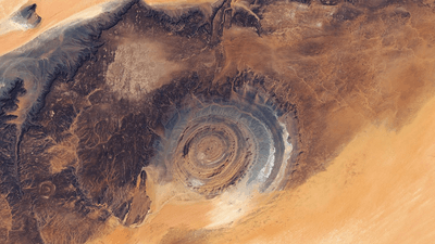
NASA has shared a new image of the Richat structure, the massive circular structure seen in an area of the Sahara Desert dotted with ancient Paleolithic stone tools and Neolithic cave paintings.
On the northwestern edge of the Taoudeni Basin, on the Adrar Plateau of the Sahara, there is a structure so unusual in appearance it has been thought to be the site of an ancient impact event by serious scientists, and the site of the legendary lost city of Atlantis by fringe conspiracy theorists.
The Richat structure, or the "Eye of the Sahara" depending on how dramatic you are feeling at the time, was first described by geologists in the 1930-40s. Back then, it was termed the "Richat buttonhole". But it wasn't until NASA's Gemini era of human spaceflight that the full 45 kilometers (28 miles) across structure could be appreciated, and captured the intrigue of the world.

In 2022, the structure was listed as one of the top 100 geological heritage sites around the world by the International Union of Geological Sciences (IUGS), which noted its beauty, as well as scientific value.
"It is one of the most spectacular examples of magma-induced ring structures in the world," the IUGS said in its heritage list. "It is aesthetically beautiful and unique geological feature whose outline is pronounced by the contrasting landscape of the wider Sahara Desert."
For a time, the structure was thought to be an impact crater, but later studies suggest a more terrestrial origin.
"Researchers later showed that it is actually a deeply eroded geologic dome formed by the uplift of rock above an underground intrusion of igneous material," NASA's Earth Observatory explains. "Over time, differing erosion rates among rock types in the exposed upper dome led to the development of circular ridges known as cuestas. The orange and gray colors reflect differences in sedimentary and igneous rock types across the structure and the surrounding landscape."
There have been attempts to link the structure to Atlantis, largely thanks to the circular shape matching very loosely Plato's description of Atlantis, a rhetorical, fictional city invented by the philosopher to rival his beloved Athens. However, there are plenty of circular structures in nature before we start screaming "ATLANTIS" at every circle we see out there, and besides, the location described by Plato (of the fictional city) does not scream the Sahara. Nevertheless, it's an interesting structure in its own right, without slapping an ancient legend on there.
"This circular geologic feature is thought to be caused by an uplifted dome—geologists would classify it as a domed anticline—that has been eroded to expose the originally flat rock layers," according to NASA. "In this type of geologic structure, rocks exposed in the center of the 'bullseye' are older than rocks forming the outer rings."
The new image was taken by the OLI (Operational Land Imager) on the joint NASA-US Geological Survey Earth observation satellites, Landsat 9 and Landsat 8, on March 5 and 6, 2026.