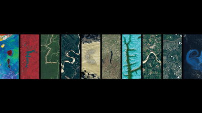


Here at IFLScience we enjoy a little interactive internet quiz or poll just as much as the next person, from finding out if we see the same color blue as each other to testing the Earworm Eraser after one too many TikToks. Now, the Landsat series of satellites is getting in on the action with an online interactive that lets you spell your name in features of Earth’s surface.
The rest of this article is behind a paywall. Please sign in or subscribe to access the full content.Made using images from the NASA Earth Observatory, NASA Worldview, United States Geological Survey (USGS) EarthExplorer, and European Space Agency Sentinel Hub, users can find topological features to spell out the letters of their name or any word they choose. Since the land on Earth covers around 150 million square kilometers (58 million square miles) there’s a lot of scope to choose from.
The Landsat Program began on July 23, 1972 to help document changes to Earth’s surface from things like commercial development, as well as climate change and natural disasters. It is the “world’s longest continuously acquired collection of space-based moderate-resolution land remote sensing data,” explains the USGS.
The project is a joint operation between the USGS and NASA with many iterations of satellites contributing to the data pool. Its main objective is to collect many images of the same places, allowing the changes over time in certain areas to be monitored.
“If you really want a long history of understanding any process on Earth, Landsat is where you should go,” said Tasso Azevedo of the MapBiomas Initiative.
Landsat 9 was launched in September 2021 and continues to contribute to more than 50 years of Landsat satellite data, including on pressing issues like sea ice decline and glacier retreats.
The IFLScience name features an “i” from Etosha National Park, Namibia, a “c” from Black Rock Desert in Nevada, and an “e” from the firn-filled fjords of Tibet.
So go on, see what features spell your name here.