

With satellite imagery of pretty much every corner of Earth readily available, we are used to the whole of planet Earth being known to humans. But it wasn't that long ago, in the grand scheme of things, that we didn't know about the continent of Antarctica.
The rest of this article is behind a paywall. Please sign in or subscribe to access the full content.That discovery – for the Northern Hemisphere, at least – came in 1820, when Russian explorer Thaddeus von Bellingshausen described seeing an "ice shore of extreme height" during an expedition to Antarctic waters. But the last major discovery of a major landmass – and certainly an archipelago – came nearly a century later, and it wasn't explored and mapped until the 1930s.
In 1910, the Imperial Russian Navy began a five-year Arctic Ocean Hydrographic Expedition. The mission was to explore and chart the Northern Sea Route, with the hope of making it into a commercial shipping route. It was not easy work. During the expedition, Russian naval officer Georgy Brusilov and 23 crewmembers attempted to navigate the Northeast Passage using a schooner, but hit thick ice floes in the Kara Sea, north of Siberia, and became trapped within them.
The crew, who were stranded in mid-September 1912, decided to stay in the ice (options were limited) and wait until the spring, hoping that they would be able to move their vessel after the ice began to melt. But the following summer, the ship remained stranded in the ice. Worse, the ice was slowly drifting further and further north, taking the ship and crew with it.
After staying another winter, 11 members of the crew abandoned the ship on the ice, and began to walk across it. Only two crewmembers – navigator Valerian Albanov and sailor Alexander Konrad – survived, having made it to Cape Flora in Franz Josef Land, where they were rescued by Georgy Sedov’s expedition.
Icebreaker ships Taymyr and Vaygach hit problems too, though they had far better luck than the doomed Brusilov expedition. On September 1, 1913, the ships encountered a field of solid ice on the east coast of Poluostrov Taymyr, forcing them to turn north in an attempt to navigate around it.
The following day, they spotted the first of what turned out to be the first of many newly-discovered islands. The crew briefly landed there, naming the island Ostrov Tsesarevicha Alekseya, before they moved on, again heading north. As they did so, they were met with a new mystery, encountering large icebergs on their journey, despite no known glaciers in the vicinity. That night, Dr L. M. Starokadomsky was on the bridge when the mystery was quickly solved.
"Dawn was breaking, but the horizon was still hidden in fog. And suddenly, ahead and a little to starboard of our course, I began to make out the vague outline of a high coastline. Or could I be mistaken?" Starokadomsky wrote of the sighting.
"Was I the victim of an optical illusion? Without saying a word to Gyune for the moment (the warrant officer had noticed nothing) I strained my eyes and peered intently into the darkness. No, there could be no mistake. I could definitely see land – the outline of the abrupt, high landmass had not changed, and was now very distinct. Snow patches could be seen on the mountains. Ahead of me, without a shadow of doubt, lay a high mountainous coast."
The crew changed course and headed towards the island, a landmass that had been missed and left unexplored by humans, as far as we know in recorded history. We now know, thanks to these explorers, that there are five main islands making up the archipelago of Severnaya Zemlya: October Revolution Island, Bolshevik Island, Komsomolets Island, Schmidt Island, and Pioneer Island.
Though missed by many explorers of this part of the world, the archipelago is by no means small.
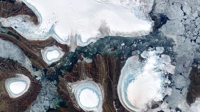
"The Severnaya Zemlya archipelago in the Russian high Arctic spans 37,000 square kilometers [14,286 square miles] – about the same area as the U.S. state of Indiana," NASA explains. "You won’t find any trees growing here. This is Arctic tundra, and cold, dry conditions prevail throughout the year. The average daily temperature in August, when this image was acquired, is 0 degrees C (32°F). Such conditions are quite favorable for year-round ice, which covers about half of the archipelago."
The islands, and further smaller islands making up the archipelago, were not properly mapped until the 1930s, by the expedition of Georgy Ushakov and Nikolay Urvantsev. The islands are home to low-lying lichens, mosses, and bushes, and plenty of birdlife, with the most-numerous being cliff-nesting seabirds. Polar bears have been sighted on the islands, as well as collared lemmings and arctic foxes, though the vegetation is so limited that animal life is sparse.
Though it is pretty cool to discover a new land, it is not fit for permanent human occupation. It remains empty of people, other than occasional research scientists drawn to the last archipelago found by humanity.