

Rivers do all sorts of strange things, from flowing backwards to changing course, and sometimes these changes can be brought on by seismic events such as earthquakes. A new study has revealed how a major earthquake 2,500 years ago caused one of the biggest rivers on the planet to abruptly change course – a little body of water we know as the Ganges.
The discovery is something of a breakthrough, as while we’ve long known about rivers changing course – something known to science as avulsions – before now it hadn’t been confirmed that earthquakes could be the driving force. And certainly not for anything as immense as the Ganges River.
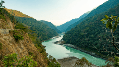
Today the Ganges flows for over 2,575 kilometers (1,600 miles) from the Himalayas down to the Bay of Bengal. It forms the world’s second-largest river system as it teams up with other rivers including the Brahmaputra and the Meghna, topped only by the Amazon as measured by discharge.

It's hard to imagine such a watery behemoth moving, but course changes that span decades or several floods are part and parcel of a river’s lifetime. That’s because sediments washed from upstream can change the lay of the land, raising the riverbed until the water finds a path of less resistance by flowing in a slightly different direction.
Avulsions needn’t be such lengthy processes, however, as this new study has revealed how earthquakes can lead to course changes that happen almost instantaneously. Looking at satellite imagery, the team discovered what appeared to be a former main channel for the Ganges running parallel to the river as it runs today for around 100 kilometers (62 miles).
They were exploring the area in 2018 when they spotted something interesting along the retired river’s flank: sand volcanoes. Known as seismites, they’re characterized by strips of sand emerging vertically through horizontal layers of mud and are a known side effect of earthquakes.

They found seismites across a large expanse of land and all of them seemed to have similar patterns, indicating they were created at the same time. Chemical analysis of the seismites revealed they date back 2,500 years, when what the researchers suggest was a magnitude 7 or 8 earthquake reshaped the landscape.
As for the source of the Ganges-shifting earthquake, it could have originated from a subduction zone to the south and east where part of the oceanic crust is working its way underneath Bangladesh, Myanmar, and northeastern India. Alternatively, large splay faults at the base of the Himalayas may have been the driving force – a concerning possibility as research suggests these zones could be due another earthquake similar in magnitude to that which changed the course of the Ganges.
Earthquakes are incredibly deadly, having the capacity to shift water inland and out to sea as they unleash catastrophic tsunamis. As such, lots of research is going into trying to better predict when these natural disasters are coming, including digging into the geology of subduction zones that can trigger megathrust earthquakes.
It’s groundbreaking research, both figuratively and literally.
The study is published in the journal Nature Communications.