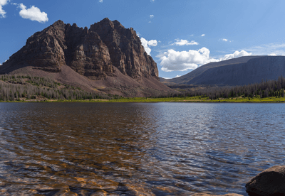


Rivers always take the easy route. Most start in the highlands before submitting to gravity and flowing down towards the sea, weaving around whatever obstacles they might find in their path. But the Green River isn't like most rivers. Instead of taking the easy route around the massive Uinta Mountains in Utah, it carves through the middle of the rocky range, before joining up with the Colorado River.
The rest of this article is behind a paywall. Please sign in or subscribe to access the full content.In a new study, geologists from the University of Glasgow have attempted to solve the mystery of this so-called “uphill” route. The answer, they say, might have something to do with Earth’s crust behaving a bit like soft wax, dipping down and rising again over a period of millions of years.
As the landscape stands today, the Green River's path defies all logic. It snakes through the US states of Wyoming, Utah, and Colorado for around 1,170 kilometers (730 miles), but rather than passing around the Uinta Mountains in northeastern Utah, it creates a 700‑metre (2296-foot) deep canyon through the 4-kilometer-high peaks.
The river likely took this path between 8 and 1.5 million years ago, long after the mountain range formed some 50 million years in the past. So why would it burrow this vast canyon, over millions upon millions of years, when the path of least resistance would simply take it around one side?
To answer this question, the researchers looked into the possibility of “lithospheric dripping”, a phenomenon that causes mountains to subside and rebound over millions of years. Using a combination of seismic imaging and advanced modeling, they showed that the region has undergone huge geological changes in this timespan.

The team found a distinct "bullseye" pattern of uplift around the mountains, and they also discovered that the crust beneath the mountains is several kilometers thinner than expected. The "missing" rock matches the 400-meter (1,312-foot) drop in elevation needed to explain the river's unusual path.
In other words, the land beneath the Uinta Mountains temporarily sagged downward as the crust “dripped” into the mantle, allowing the Green River to establish its course through the range. As the land slowly rebounded, the river managed to hold its route, cutting straight through the rising mountains.
The consequences of this unusual origin have left a big imprint on the continent. When the Green River met the Colorado River, it fundamentally reshaped the geography and biology of the entire region.
As Dr. Adam Smith, lead study author from the University of Glasgow’s School of Geographical & Earth Sciences, explained in a statement sent to IFLScience: “The merging of the Green and Colorado Rivers millions of years ago altered the continental divide of North America. It created the line that separates the rivers that flow into the Pacific from those that flow into the Atlantic, and created new habitat boundaries for wildlife that influenced their evolution. It’s an enormously significant area of the continent.”
“For about 150 years now, geologists have debated over exactly how the rivers merged, which is a particularly challenging question for a tectonically inactive area where major geological events are rarer. We think that we’ve gathered enough evidence to show that lithospheric drip, which is still a relatively new concept in geology, is responsible for pulling the land down enough to enable the rivers to link and merge,” he said.
The research is published in the Journal of Geophysical Research: Earth Surface.