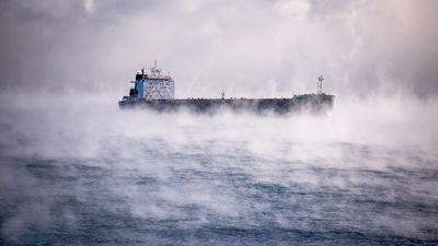
In the last few days, arctic air has brought below-freezing temperatures across many parts of the US, including Chicago and Lake Michigan. There, people noticed a very peculiar phenomenon: "Steam" appeared to form above the Chicago River and the lake. Prompting many to ask (maybe in the style of 4 Non Blondes): what’s going on?
The first thing to say is that it is not steam. Steam is water vapor released when water is heated. What you are seeing is indeed water vapor – but we ought to be pedantic about its formation. The phenomenon you are seeing is closer to seeing one’s breath on a cold day. You probably wouldn’t describe yourself as steaming.
Smoke on the Water
Watching the video (or if you are in Chicago or somewhere with equally cold weather and flowing water), you are witnessing water vapor condensing over the surface of the water. This has been previously called sea smoke, but it is a lot more similar to fog than anything else.
It forms due to the temperature difference between the cold air and the warmer water. At the boundary between the two, a thin layer of air forms, and in it there is some water vapor. Warm air rises, and the water vapor, suddenly in contact with colder air, condenses into fog in wispy structures across rivers, seas, and lakes.
The best conditions happen when there is a big difference in temperature between the air and the water, like in Chicago right now. And it is easier when there’s little wind so that the condensation has time to take place and it is not immediately blown away.
A More Technical Science Lesson Is Dew
So why do you need those conditions for the formation of sea smoke? That has to do with the dew point. The amount of water vapor needed to saturate a certain volume of air depends on the temperature. The cooler it is, the easier is to get to the dew point. Beyond that, water vapor starts to condense. At high altitudes, we call this condensation clouds. At ground level, we call it fog.
Fog and sea smoke are related, but fog forms in the opposite way – warm air over cold water. Another similar phenomenon to sea smoke is the sublimation of ice when in direct sunlight.
All “explainer” articles are confirmed by fact checkers to be correct at time of publishing. Text, images, and links may be edited, removed, or added to at a later date to keep information current.