Scientists have now fully mapped a legendary lake in New Zealand that was once an important setting for a famous Māori love story. Their analysis reveals never-before-seen details about the deep hydrothermal systems that are concealed below its disarmingly peaceful surface.
Peaceful water and violent histories
Lake Rotorua (Te Rotorua nui ā Kahumatamomoe in Māori) is a special place. It is the second-largest lake on New Zealand’s North Island and was formed by the violent explosions of a now dormant ancient volcano. Around 200,000 years ago, that volcano experienced a massive eruption, which caused its underlying magma chamber to collapse, creating a large 9.94 mile (16 kilometers) wide caldera. Then, around 65,000 years ago, the crater filled with water to form Lake Rotorua, which has been at its current level for the last 22,000 years.
Despite its beauty, Lake Rotorua is still home to hydrothermal activity that reminds us of the violent volcanic processes that created it. In fact, some have described how its waters sometimes have clouds of steam drifting across them and that the lake’s heavy sulfur content gives it a “magical green-blue” appearance.
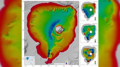
Now, researchers at GNS Science, a New Zealand-based institute, have mapped Lake Rotorua’s floor and revealed new details about its ancient base. According to their work, the lake hides thousands of “pockmarks” – essentially, smaller caters – some of which were 50 meters (164 feet) in diameter. These pockmarks mark where gas bubbles have disturbed the sediment on the lake’s floor.
The map also shows evidence of an ancient river that predates the lake. The river can be seen meandering off the shore of Sulphur Point and then winding west of Mokoia Island before curving northeast. The island, which was formed by a rhyolite dome created by slowly flowing lava, is now a lush green environment that serves as a sanctuary for many of New Zealand’s endangered wildlife and rare birds.
It is also steeped in cultural significance for the Te Arawa people, who see it as a sacred space. Importantly, Mokoia Island is the setting for one of the most famous legends in New Zealand, the love story of Hinemoa and Tūtānekai.

Magnetic anomalies
In total, the maps cover around 21 square miles (55 square kilometers) and account for about 68 percent of the lake’s floor. The mapping process was achieved through various techniques, some of which were performed by the New Zealand Navy; they used multibeam sonar to map the lake’s physical features and also conducted magnetic surveys of the lake floor. This latter technique revealed interesting magnetic anomalies towards the center of the lake.
Under normal conditions, volcanic rocks contain magnetite, a mineral (not to be mistaken for the similarly named Pokémon) that is highly magnetic and aligns itself to Earth’s magnetic field. However, in places like Lake Rotorua, hot water can pass through the rock and transform magnetite into pyrite (fool’s gold), which has pretty much no magnetic signal.
“Normally with volcanic rocks, when you run a magnetometer over the top of them, you get very positive anomalies, but in this case we're getting negative anomalies, likely due to very low magnetic susceptibilities,” Dr Cornel de Ronde, a principal scientist at GNS, told Live Science.
This anomaly seems to coincide with a “subtle heat flow anomaly”, researchers explained in a statement, which hints at a "possible igneous intrusion and another hydrothermal system nearby—exciting clues as to the hydrothermal processes at play beneath the lake floor.”
This could explain why there is a negative anomaly in that part of the lake.
“We are excited not only for how these new maps broaden our collective knowledge of region,” said the researchers, “but also celebrate the iconic landscape and will contribute to further study in the future.”