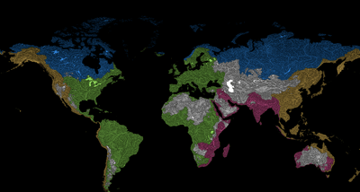


Feast your eyes and gorge your brain on these beautiful maps showing which ocean each river in the world flows into.
They were crafted by Grasshopper Geography, best known as the creators of the vibrant maps that illuminate the flowing river basins of Earth’s continents. Now, they’re back with a new set of maps showing the world's rivers divided into ocean drainage basins.
“I've never found a global map of rivers showing which ocean they all end up in, and I decided years ago that I'll just make one myself. This project's been going on in the background for months,” Robert Szucs, digital cartographer turned artist and founder of Grasshopper Geography, said in a statement sent to IFLScience.

“After hundreds of hours of data editing and mapmaking, I'm finally ready to show this set of maps to the world. I hope people will love it, both as art and as educational material,” he added.
Along with providing a global world-view map, there are also individual breakdowns of some countries where the river drainage situation is not so straightforward, including Syria, Ethiopia, Mexico, Iceland, Australia, and Canada.
 and the Arctic Ocean (blue.)")
A particularly interesting example is the US. As you can see through the vibrant colors of the map, below, the rivers of the US ended up in the Pacific Ocean, the Atlantic Ocean, and the Arctic Ocean.
There is also a region in the west called the Great Basin, which is an endorheic basin, meaning it is a region where the river network is completely isolated from the world ocean.
, the Atlantic (green), and the Arctic (blue.)")
A giant endorheic basin can be seen encompassing much of Western and Central Asia. This is primarily due to the presence of the Caspian Sea, the world's largest inland body of water, which drains much of the Volga, the longest river in Europe.
That old adage that “rivers always meet the sea” isn’t true, after all.