Nature
 PUBLISHED




The world is currently in the midst of the biggest Super El Niño event in recorded history, a global climate phenomenon that’s bound to influence weather towards the end of 2026. However, the latest seasonal forecasts for the coming fall in the US are “surprisingly muted” and not exactly what meteorologists were anticipating.
The National Weather Service's (NWS) Climate Prediction Center has just released its weather projections for the US across September, October, and November.
At a national scale, temperatures are set to be warmer than usual, with cooler-than-average weather looking very unlikely across most of the country.
Above-normal temperatures are likely for most of Alaska, the western and central parts of the Lower 48, the Northeast, the Mid-Atlantic, Florida, and coastal areas of the Southeast and Gulf. The strongest confidence can be found in the Pacific Northwest, Northern Rockies, and northwestern California, where the probability of warm weather is over 50 percent.
Meanwhile, a small pocket of the Great Lakes region, the Ohio Valley, and the Mid-South area is the "Equal Chances" zone, in which temperatures may or may not rise above average.
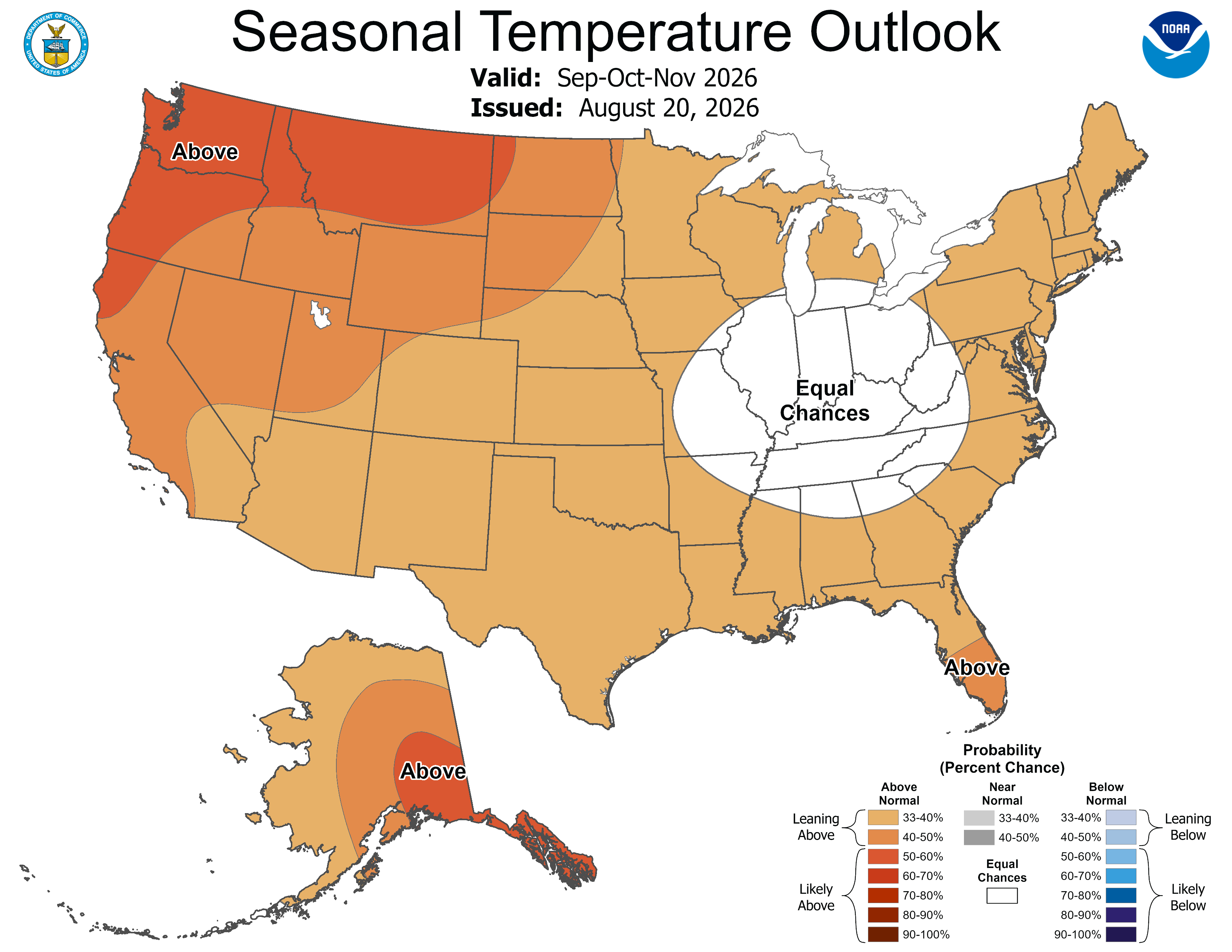
This might seem a bit hazy, but remember that meteorologists can only make “skillful forecasts” within 14 days or so. As summer comes to a close, these fall forecasts should come into focus a bit more.
Precipitation-wise, you can expect wetter-than-normal conditions in the Southwest, parts of the Southeast, and western Alaska, with the strongest signal (over 40 percent chance) across Arizona, Colorado, and New Mexico, as well as Georgia and South Carolina.
This means we could see early-season snow potential at elevated parts of Colorado, Arizona, and the Sierra Mountains, as well as Alaska, which is no stranger to snowy weather.
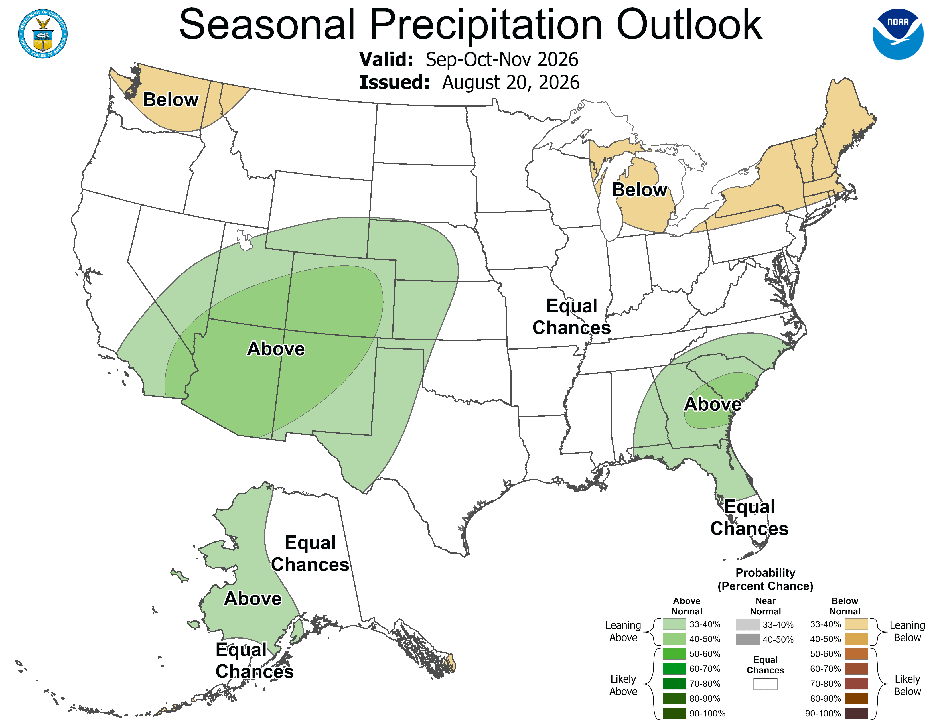
This forecast aligns loosely with El Niño's expected footprint on weather in North America.
In the US, El Niño typically pushes the jet stream south, bringing warmer and drier conditions in the North. Meanwhile, wetter conditions are more likely in the Gulf Coast and Southern California, while triggering drier winters in the Pacific Northwest and northern states.
In 2026 and 2027, however, the world is being hit by an especially strong El Niño, meaning its effects on global weather are theoretically set to be heightened.
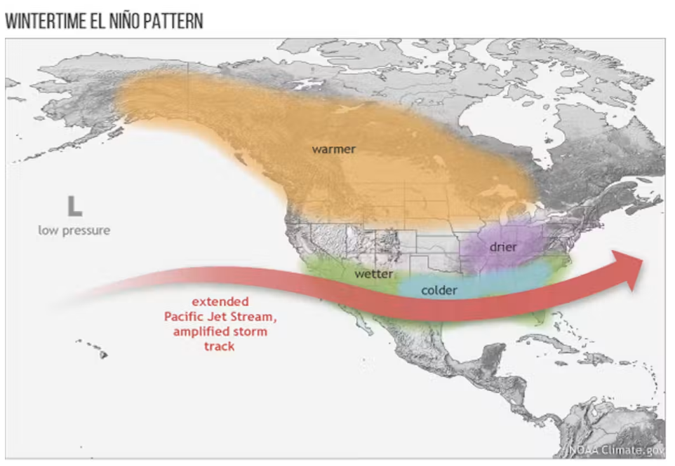
El Niño is a climate phenomenon characterized by warmer ocean temperatures across the central and eastern tropical Pacific Ocean, triggering a domino effect that has a broad influence on the weather across the world.
Scientists officially declare the emergence of El Niño when sea surface temperatures in this part of the Pacific rise to at least 0.5°C (0.9°F) above the long-term average, which happened in June 2026.
However, this El Niño has continued to muster strength at a remarkable pace despite still being relatively young. In the first week of August, temperatures in the eastern Pacific were 2.6°C (4.68°F) above normal.
Speaking to IFLScience in early August, Zeke Hausfather, a climate scientist at Berkeley Earth, said the situation is “uncharted territory,” adding there's simply no historical comparison to draw on to understand how this might pan out.
“I don't want to be overly alarmist about it, but I think we should be preparing right now for something that we have never seen before,” said Hausfather.
“I hope countries, particularly in the tropics, are already starting to prepare for reduced harvests and the impacts that'll bring. I don't think we can be complacent, particularly because this event is so far outside of anything we've experienced before,” he added.
Granted, this latest seasonal outlook from the NWS Climate Prediction Center may look remarkably unremarkable at first glance and hardly catastrophic, but it confirms a strong El Niño is now in place and poised to shape conditions as 2026 gives way to 2027, even if the impacts seem "surprisingly muted" for now.
“Despite the magnitude of this El Niño, temperature impacts are surprisingly muted during the fall season, even among strong events, as the greatest impacts tend to express themselves during the winter months,” commented the NWS.