

It's official: Spring has sprung in the US, as early as three weeks prior to normal in some parts. The United States Geological Survey (USGS) has released a pair of scientifically-backed maps to help you see immediately where and when this unseasonably early spring bloomed across the US, based on their data of temperature-sensitive flowering plants.
As you can see in the GIF map (below), spring has hit across the southern Great Plains and the southeast Atlantic Coast. In Washington DC, it arrived 22 days earlier than historical norms. Spring is currently tearing up across coastal California, southern Nevada, southeastern Colorado, central Kansas, Missouri, southern Illinois, Indiana, and Ohio. It’s also well underway in West Virginia and Virginia. It looks like Philadelphia and Indianapolis will be next.
Watch how it crept up on Amercia in the two maps below.

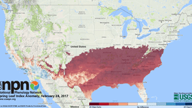
Spring, it has sprung. USGS, SA-National Phenology Network.
 The Spring Leaf Index is a measure of these early season events in plants, based on recent temperature conditions. The map shows locations that have reached the requirements for the Spring Leaf Index model NOAA National Centers for Environmental Prediction Real-Time Mesoscale Analysis temperature products