If you're considering purchasing a home in the near future, a new analysis suggests you may want to consider the effects and costs of future climate change predictions on where this home may be.
A new study by Climate Central and Zillow suggests 350,000 US homes worth an estimated $190 billion currently reside on land that is at risk of yearly flooding by 2050 – and that’s if strategies to mitigate future emissions are put into place. If left unchecked, climate change will impact more than 386,000 homes.
The findings are relevant to those who may be considering purchasing a new home – 2050 is just a standard 30-year fixed mortgage away, after all. And if you’re looking at buying in major cities like New York, Miami, and the San Francisco Bay Area, then you may be disproportionately affected.
The country-wide analysis looked at the intersect of areas that are prone to flooding from rising seas and storm surges in comparison with Zillow’s residential property data, counting the number and types of homes along with their current value. A “risk-zone” was defined as a home at or below sea level where annual chronic flooding is expected to occur.
This map suggests the former “medium emissions” projection where greenhouse gasses peak around 2040 and decline sharply thereafter. As the authors note, local factors can affect a home’s risk level, including the local population, the economy, as well as space available for future development.
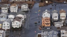
Even in the face of worsening natural disasters, many coastal communities are seeing a surge in construction in at-risk zones compared with safer areas. For example, the state of New Jersey has seen its housing growth rate increase more than three times that of coastal flood risk areas to the tune of 2,700 new homes at an estimated $2.6 billion following one of the country's costliest superstorms, Hurricane Sandy. Similar trends are occurring in nine other states, with more than half of the country’s coastal areas seeing higher rates in flood-risk areas.
A study earlier this year found similar results. With emissions left unrestrained, the Union of Concerned Scientists estimates an average sea level rise of 0.6 meters (2 feet) by 2045, with the trend being expedited at the end of the century putting 2.4 million homes worth about $1 trillion at risk.
[H/T: Buzzfeed News]