

Volcanoes erupt all the time. Many of you already know this, but we’re willing to bet that very few can truly grasp the ridiculously high frequency with which they occur.
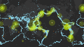
Collating every single volcanic eruption that has taken place from 1960 to 2016, a team of researchers from the Global Volcanism Program (GVP) at the Smithsonian has produced a stunning animation revealing just how violent our planet’s fiery mountains and titanic tectonic plates have been.
Check out the interactive animation here.
Called Eruptions, Earthquakes, and Emissions (E3), it allows users to watch as the world shakes and burns and, from 1978 onwards, how it’s covered in sulfur dioxide emissions leaking out of those major volcanic edifices. If you’re curious to learn more about any of the individual events, you can click on one of the eruptions or earthquakes to see more information about it.
It’s updated continuously with the help of cutting-edge data from the United States Geological Survey (USGS), which means that there really is nothing else like this out there.
At first glance, it appears that the symphony of volcanic explosions and effusions is fairly chaotic and without any sort of discernible pattern. The most powerful, infrequent type of volcanic eruptions and quakes are very difficult to predict, and initially, E3 appears to paint a picture of pandemonium.
However, there are patterns that begin to emerge. Volcanic eruptions clearly appear along set lines for the most part, and these are invariably tectonic plate boundaries that feature either subduction zones – where an oceanic plate sinks and disintegrates beneath a continental plate – or along a rift zone, featuring two plates moving apart.
For a variety of reasons, the volcanism that appears above these two types of margins is quite different, with that emerging above subduction zones being particularly viscous, gas-rich, and explosive. Watch out for some incredibly powerful blasts appearing on the animation along these regions, including the famous “Ring of Fire” around the Pacific Ocean.

That's a lot of fireworks. Global Volcanism Program/Smithsonian/USGS
Certain volcanoes form above mantle plumes, upwellings of superheated material emerging from the boundary between the mantle and the liquid core. These so-called “hotspots” can appear anywhere on the planet and produce a range of long-lived volcanoes, from those that emit a ludicrous volume of lava (Hekla, Iceland), sometimes without stopping for decades (Kilauea, Hawaii), to supervolcanic cauldrons (Yellowstone, Wyoming).
As destructive as volcanic eruptions might sound, don’t forget that they are the creators of new crust, of new land to stand on. Just recently, a brand new island appeared off the coast of Japan. They are mainly seen as a hazard, but that’s only because we are literally standing in their way. They were erupting long before we arrived around 200,000 years ago.
Earthquakes are perhaps even more perplexing than volcanic eruptions. They occur along any plate boundary that builds up stress, including those that feature two sliding past each other in opposite directions (San Andreas Fault) or over each other in subduction zones (Japan Trench).
Weirdly, there are also intraplate earthquakes, those that happen between plate boundaries in the middle of continents (see the New Madrid Seismic Zone). Minor faults, ancient tectonic boundaries called “mantle scars”, and pushing and pulling of the entire landmass around them can trigger tremors in these unusual regions – but their mechanisms are largely mysterious. In other fault-less areas, human activity – particularly fracking – can cause fairly powerful earthquakes.
As cool as the E3 animation is by itself, researchers hope to use it to identify patterns in eruptions and earthquakes that, if they exist, haven’t been spotted yet. Do certain types of events take place at set frequencies, or along with other coinciding natural disasters?
Keep your eyes peeled, citizen scientists.

Hey hey, Hawaii. Radoslaw Lecyk/Shutterstock