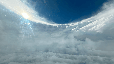


The National Oceanic and Atmospheric Administration (NOAA) has flown a plane into a hurricane to learn about these tropical storms.
The rest of this article is behind a paywall. Please sign in or subscribe to access the full content.NOAA regularly makes flights inside hurricanes to monitor them and make predictions about their progress. Using two aircraft – nicknamed "Kermit" and "Miss Piggy" – the hurricane specialists take data from inside the eye of the hurricane itself.
"The P-3s' tail Doppler radar and lower fuselage radar systems, meanwhile, scan the storm vertically and horizontally, giving scientists and forecasters a real-time look at the storm," NOAA explains. "The P-3 [planes] can also deploy probes called bathythermographs that measure the temperature of the sea."
The aircraft have been deployed to monitor Hurricane Beryl, which briefly became the earliest Atlantic Category 5 hurricane on record as it strengthened earlier this month.
Flying through hurricanes is, of course, generally not recommended, and pretty difficult to prepare for.
"It’s impossible to accurately simulate a hurricane eyewall penetration," NOAA Hurricane Hunter Commander Scott Price explained. "Doing it in the aircraft in a storm is the only way to experience the responsiveness of the plane, flight characteristics, crew coordination, and visceral response brought on by plowing through a wall of wind and rain while you’re at the controls."
As well as equipment on the plane, the team also launches tube-shaped sensor devices known as dropsondes, which transmit data back to the plane as they fall toward the ocean below.
"We use dropsondes to measure temperature, humidity, pressure and wind speed, and send back data every 15 feet [4.6 meters] or so all the way to the ocean surface," Jason Dunion, Research Meteorologist at the University of Miami explained in a piece for The Conversation. "All of that data goes to the National Hurricane Center and to modeling centers so they can get a better representation of the atmosphere."
NOAA uses this data to make predictions about the path and intensity of hurricanes. Though spectacular, they are certainly not doing it for the view.