


The Euphrates River has shaped human life for thousands of years. The farms, the cities, the laws, the gods, the science, the wars — much of today's world is downstream from here. Despite that huge legacy, scientists have never agreed on how or when it formed, but a new study may finally have an answer.
Today, the modern Euphrates flows for around 3,000 kilometers (1,864 miles) through Turkey, Syria, and Iraq before emptying into the Persian Gulf. Alongside its "sister" river, the Tigris, it forms the largest river system in Western Asia.
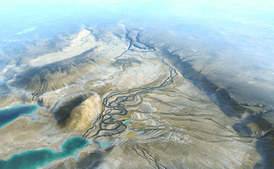
To dig into its origins, scientists looked at the modern topography of the region, paired with seismic-reflection techniques that allowed them to peer into geological structures beneath the surface. The study was conducted by Chevron, which, as a fossil fuel giant, has a vested interest in understanding the oil and natural gas locked within the geology of the Middle East.
The researchers found that the Euphrates was once two distinct river systems – the Palaeo‑Karasu and the Palaeo‑Murat – that ran across Anatolia (present-day Turkey). These rivers first flowed into shallow inland lakes, then headed southwards to drain into the Mediterranean Basin.
However, this was a very different time on planet Earth. When this pair of proto-rivers flowed, around 5 to 6 million years ago, the Mediterranean Sea had nearly completely evaporated and turned into a large salty plain, in a strange event known as the Messinian salinity crisis.

Surprisingly, the geology suggests that those two ancient rivers carried more water than the Tigris, Euphrates, and Nile rivers combined. Stranger still, they drained into a much smaller area than the modern Euphrates does. The only explanation is that the region was once much wetter and more mountainous than it is now.
The flow of the rivers changed around 3.6 million years due to tectonic movement in the East Anatolian Fault, rerouting the pair away from the Mediterranean and swinging them southeastward onto the Arabian plate. By roughly 1.6 million years ago, this slow but dramatic rerouting had produced the Euphrates River as we know it today, more or less.
Eventually, the land cradled between the Tigris and Euphrates would go on to become one of the most consequential places in human history. Known as the Fertile Crescent for its rich, productive soils, it was here that great early civilizations, including the Sumerians, Babylonians, and Assyrians, flourished. Their cities gave the world some of its earliest achievements in writing, mathematics, astronomy, and the arts.
Although once a fruitful land, the Tigris–Euphrates river system is now drying up at a startling rate, with estimates suggesting it could be gone by 2040 due to declining water levels and climate-driven droughts.
In the Bible’s Book of Revelation, the drying up of the Euphrates River signals the end times and paves the way for a final confrontation between good and evil. Science stops short of predicting the apocalypse, but the river's plight could be a very real symptom of a global crisis.
The study is published in the journal Nature Geoscience.


