

Chinese astronomers have released the most detailed atlas of the Moon ever published, which they describe as the “first high-definition geological atlas of the whole Moon”. The atlas not only provides images of the craters as can be seen from telescopes or orbiters, but offers Geologic, Lithologic, and Tectonic maps of the whole lunar surface.
The rest of this article is behind a paywall. Please sign in or subscribe to access the full content.NASA compiled detailed maps of the near side of the Moon prior to the Apollo missions and released these to the public to adorn many classroom walls, with higher resolution versions available to enthusiastic amateur astronomers. However, just as lunar exploration ground to a halt for decades, the same is true for accessible maps. Now, however, both are changing as nations race to outdo each other.
Years of operation by lunar orbiters equipped with sensors much more advanced than were available in the pre-Apollo days have produced a wealth of new information about the Moon.
“With the accumulation of data and research results, these lunar geological maps may no longer meet future scientific research and lunar exploration needs,” said the atlas's editor-in-chief Liu Jianzhong of the Institute of Geochemistry of the Chinese Academy of Sciences in a statement.
Liu has overseen the production of geologic Moon maps at a scale of 1:2.5 million so that every centimeter on the map is equivalent to 25 kilometers (15.5 miles). In addition to detailed maps of 30 quadrangles of the Moon, there are maps of the entire lunar surface for visualizing at once, albeit somewhat distorted near the poles.
Although the Moon does not have active plate tectonics moving against each other like the Earth, it preserves what Liu and colleagues call “tectonic units” from early in its formation. The Tectonic Map reveals their locations, along with an explanation of the classification system for lunar structures.

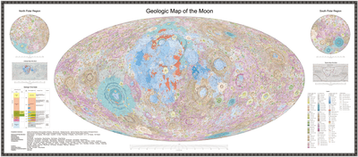
The Lithographic Map marks out different rock types by color, while the Geologic Map is the most familiar, identifying the craters, their composition, and the timing of their formation.
.png "The Lithographic map shows the Moon in a new way with the different types of rocks shown by their color")
In the process of producing these maps, the team came up with their new timeline for the Moon, breaking lunar geologic history into three eons and six periods, which they argue is more objective than previous timelines.
The new timeline emphasizes the importance of the shift from the Moon’s youth, when change was driven from within (endogenic), to the much longer period of domination by external influences such as asteroid impacts (exogenic). The creators of the atlas say this distinction also helped them classify the lunar structures and rock types to make the different sorts of maps.
In addition to marking 12,341 impact craters, 81 impact basins, 17 types of rocks, and 14 types of structures, the atlas-makers classified the basins based on the processes of their formation. They’ve also included important markers of the new era, which some people call the Moon’s own Anthropocene, with the sites of lunar landings, both by people and machines.

The potential of the atlas, which is available in both Chinese and English, for education is obvious, particularly in the event that the forthcoming human landings spark global interest. However, the makers also see it as a tool for “Lunar scientific research … landing site selection, lunar resource exploration and trajectory planning for China’s future lunar exploration projects.”
The Atlas is available from the Geological Publishing House, but it's probably not a birthday present for the Moon-lover in your life unless you're very rich.