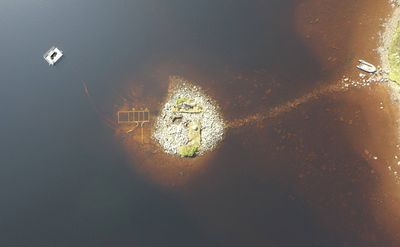


Around 5,000 years ago, before Stonehenge was built, people living on the Isle of Lewis in Scotland built a small island in a loch. Now, researchers have excavated this tiny structure and found a large timber platform hidden beneath its stony surface.
The rest of this article is behind a paywall. Please sign in or subscribe to access the full content.To say humans like water is probably a bit of an understatement. More than half of the world’s population lives less than 1.8 miles (3 kilometers) from freshwater, while over one-third are within 62 miles (100 kilometers) of a coastline.
Areas surrounding water have long been important habitats for our species, particularly along “littoral margins” – dynamic zones between land and water, including beaches, shorelines, estuaries, and salt marshes. These environments often hold diverse resources while offering means for movement, making them ideal sites for settlement and interaction.
As such, finding reliable archaeological data from these zones can offer valuable insights into historical shifts in the density and organization of human socioecological systems.
But finding them can be tricky. Water presents a barrier for many archaeological tools that are otherwise effective on land. At the same time, marine geophysical equipment can struggle to deal with anything at depths of less than 1 meter (3 feet).
But in a new study, researchers at the University of Southampton and the University of Reading turn their attention to a peculiar human structure that appears in the shallow waters of many Scottish lochs. Crannogs, as they’re called, are small artificial islands that were built on lakes, bogs, lochs, or estuaries in ancient Ireland, Scotland, or Wales. It is unclear exactly why these sites were built, but they were used and reused by different generations from the Neolithic period through to the Iron Age and beyond.
In this instance, the researchers examined a 5,000-year-old crannog in Loch Bhorgastail on the Isle of Lewis. This site offered them a chance to explore practical solutions to the challenges usually posed by water when it comes to archaeology.
Using a technique called stereophotogrammetry, which creates accurate three-dimensional models by assessing overlapping two-dimensional photographs taken from different angles, the archaeologists were able to record the island both above and below the waterline as a single, continuous structure. This provided a unique perspective that wouldn’t have been possible using other techniques.
The fieldwork uncovered a layered wood and brushwood construction under the island’s stone capping, along with hundreds of pieces of Neolithic pottery in the surrounding water.
Over several years of analysis using traditional excavation techniques, coring, surveying, and radiocarbon dating, the researchers have been able to piece together different stages of development for the crannog. They’ve established that it is older than some of the most well-known monuments in the British Isles, such as Stonehenge.
They believe it started out as a circular wooden platform that was around 23 meters (75 feet) across. This structure was topped with brushwood. Then, around 2,000 years later in the Middle Bronze Age, another layer of brushwood and stone was added before another phase of activity occurred a further 1,000 years later. The island was, for a time, connected to the shoreline by a stone causeway, but this is now underwater.

Archaeologists have also discovered hundreds of pieces of Neolithic pottery from bowls and jars at the site.
“While we still don’t know exactly why these islands were built, the resources and labour required to construct them suggests, not only complex communities capable of such feats, but also the great significance of these sites. Large quantities of pottery, often still containing food residue, and worked stone found on and around the islands, suggest their use for communal activities such as cooking or feasting,” Dr Stephanie Blankshein, C&IW Heritage Science Facilities Manager and lead author, explained in a statement.
Overcoming watery challenges
The researchers’ new stereophotogrammetry technique was designed and used during fieldwork in 2021.
Photogrammetry is a well-known method of creating three-dimensional computer imagery using multiple two-dimensional photos, but using it in shallow water is extremely difficult.
“Fine sediments, choppy conditions, floating vegetation and distorted or reflected light all hinder shallow water imaging. Photogrammetry is very effective in deep water but runs into problems at depths of less than a metre. This problem is a well-known frustration for archaeologists,” Professor Fraser Sturt, Principle Investigator and Director of the Southampton Marine and Maritime Institute, explained.

To address this, the team used two small waterproof cameras with low-light performance and a wide-field of view. They locked these cameras at a set distance apart on a frame, creating a “stereo” method that produced overlapping images. This helped them compensate for any missing or disrupted data.
The cameras were then moved through the water by divers with positioning controlled to centimeter accuracy, which matches that of aerial drones.
“By combining stereophotogrammetry, drone technology and some innovative post-processing of the data, we have managed to set out an accessible approach that is portable and cost effective,” Dr Blankshein added.
This achievement has provided extra clues to the mysteries surrounding the crannog; the team hope to use this method to investigate similar structures at other sites.
The study is published in Advances in Archaeological Practice.