

It's one thing to hear about the impacts of climate change through sensationalist headlines or incomprehensible scientific papers, but it's quite another to see the profound changes with your own eyes.
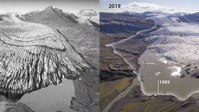
A new project by researchers from the University of Dundee, the University of Iceland, and the Iceland Meteorological Office has highlighted the scale of ice loss Iceland’s glaciers are experiencing by comparing aerial photographs taken in the 1980s with present-day drone images.
“It is important to show how climate change is physically and visibly affecting the region. To do this, we developed a novel process based on principles that are used by glaciologists to measure ice-volume loss. This method allows us to compose unique aerial views of past landscapes and to see how they have changed over the last 30 to 40 years,” Dr Kieran Baxter from the University of Dundee said in an emailed statement.
"While we have a fantastic resource of mapping photographs from the 1980s, this method can also be applied to aerial photographs that are even older. The archives are huge and we have barely scratched the surface in terms of using them to better show how the warming climate is revealed in our landscapes."

The work tells the story of the south side of the Vatnajökull ice cap, the largest ice cap in Iceland and the second-largest in Europe, over the past three decades. Beneath the ice cap, you can also find several volcanoes. If these volcanoes erupt then it can burst the ice and cause a glacier outburst flood, or what's known in Iceland as a jökulhlaup.
Vatnajökull covers an area of 7,700 square kilometers (4,784 square miles), approximately 8 percent of the country. However, the ice cap has started to show its fragility. Over the past few decades, scientists have documented the ice cap retreating by tens of meters, and in some areas hundreds of meters, every single year.

The culprit – you guessed it – is climate change. A recent report by the UN's IPCC found that oceans and the cryosphere (the frozen parts of the world, like ice sheets) have been “taking the heat” from climate change, absorbing over 90 percent of the excess heat in the climate system and up to 30 percent of human-induced carbon dioxide emissions.
As you can see from this recent project, the effects of this are already being felt. Iceland has almost 400 glaciers, most of which could be gone by 2200 if current global warming trends continue and greenhouse gas emissions remain chequered. The past summer, Icelanders held a funeral for Okjökull in Borgarfjörður, the first Icelandic glacier to lose its status as a glacier due to climate change.
Recently, Dr Baxter and colleagues recently carried out a similar project looking at the impact that climate change has had on Mont Blanc's glaciers on the French-Italian border. You can see the stunning, yet dispiriting, images right here.