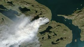


Greenland has been experiencing one of the largest wildfires in its history in the last week. The wildfire is estimated to stretch between 5 and 15 square kilometers (1.9 to 5.8 square miles), with smoke reaching up to 2 kilometers (1.2 miles) high in the atmosphere, as reported in local media.
The rest of this article is behind a paywall. Please sign in or subscribe to access the full content.The unexpected event, 150 kilometers (95 miles) from Sisimiut in Western Greenland, was also detected by both NASA and the European Space Agency (ESA). Both scientific institutions used their Earth-monitoring satellites to analyze the region from space, producing incredible views of the event as well as collecting important data regarding wildfires in the region.
According to NASA’s Earth Observatory, the first detection of fires in the region was on July 31 by the Aqua and Terra satellites. The more detailed image was then snapped on August 3 by Landsat 8. ESA’s Sentinel-2B also looked at the region on the same day.
Professor Jessica McCarthy from Miami University shared on Twitter that she thought the fire is burning through peat since it is likely common there. Another series of tweets from Professor Stef Lhermitte of the Delft University of Technology explained preliminary analysis suggests that Greenland is experiencing an unusually high number of wildfires this year.
The two researchers did some initial assessments but it will take some time to work out the bigger picture of how and why this wildfire occurred. For example, there is no certainty on what started the fire, although it has been suggested that a lightning strike might have alighted the tundra, which is currently free of ice due to the retreating glaciers.
The effects of global warming have been particularly acute in Greenland. Both the ocean and the air around the large island has become significantly warmer in the last few decades. These are both contributing to the changes Greenland is experiencing, although scientists are unsure which one, if either, is the predominant cause.
“What scientists do know is that warming Arctic temperatures – and a darkening surface of the Greenland ice sheet – are causing so much summer melting that it is now the dominant factor in Greenland’s contribution to sea level rise,” Ian Joughin, a glaciologist at the University of Washington, said in a statement.
“Greenland’s summer melt season now lasts 70 days longer than it did in the early 1970s. Every summer, warmer air temperatures cause melt over about half of the surface of the ice sheet – although recently, 2012 saw an extreme event where 97 percent of the ice sheet experienced melt at its top layer.”