

Climate change is often talked about like a distant problem for the future, which inevitably leads to the response: “eh, someone will sort it out later.” However, make no mistake about it: humans are already really, really causing drastic changes to planet Earth. If you need proof, then look no further than satellite imagery from recent decades.
NASA Earth Observatory has released a collection of satellite images that show just how drastically Earth’s geography has transformed over the past few decades. From shrinking glaciers and deforestation to forest fires and exploding hubs of urbanization, the results are stunningly obvious.
Most of the sets of images consist of one picture taken within the past couple of years compared to an image of the same area taken 10 to 40 years ago. Some of these can be considered a natural part of the climate system. After all, Earth has been constantly changing, shifting, and transforming for billions of years.
In other instances, humans are the prime culprit. One of the most obvious examples of human-driven changes is urbanization. Just take a look at the satellite images above the beachside development in Dubai, United Arab Emirates (UAE). In 2000, the coastline was not yet touched by the UAE's impending oil boom. Eleven years later, after their economy skyrocketed, the same area became caked in skyscrapers, shopping centers, hotels, and even artificial islands.
Climate change is another big contributor to anthropogenic changes to the environment. Take a look at the Glacier National Park in the Rocky Mountains of Montana. There were around 150 glaciers in the park towards the end of the 1800s. Out of the remaining 26, none are expected to survive the coming decades.
As you'll no doubt remember, 2017 saw a series of hurricanes that pummeled parts of the Caribbean and mainland US. The effects were so profound you can see the changes from satellite images. You can see a collection of images that show this here, but in the meantime, check out the newly compiled imagery from NASA Earth Observatory's World of Change series below.
The Urbanization of Dubai


Ice Loss in Glacier National Park, Montana


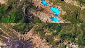
Mountaintop Mining in West Virginia


The Shrinking Aral Sea


Deforestation of The Amazon Rainforest in Western Brazil