

As a science website, it is easy to get caught up in the mysteries of vanishing stars and the crisis in cosmology, while people out there on the Internet are struggling with why flying against the planet's rotation doesn't decrease flight times, and why we can't power our trucks with magnets.
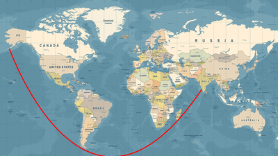
The rest of this article is behind a paywall. Please sign in or subscribe to access the full content.This week, it appears that people are struggling a little with straight lines. Late last week, X (Twitter) account Latest in Space shared a pretty uncontroversial post explaining that you can travel from India to the USA in a straight line.
Despite the line clearly being straight, people were not convinced.
Representing a 3D world on a 2D map is always going to end up with some issues and some compromises. No matter how accurate you try to make it, you will end up with stretched areas, squashed countries, or else parts of the map cut out altogether.
The map you are likely familiar with is one based on the Mercator projection, published by cartographer Gerardus Mercator in 1569. It's a cylindrical map projection, in which you place the globe into a cylinder and then project each point of the map onto a corresponding point on the cylinder. Meridians (imaginary vertical lines going through the Earth from the North to the South Pole) are mapped onto vertical lines equally spaced apart on the map, and circles of latitude (imaginary horizontal lines from east to west) are mapped onto equally spaced horizontal lines.
The Mercator projection is good for navigation because it represents courses of constant bearing as straight segments, meaning ships have to course correct for the curvature of the Earth less frequently. However, it also results in distortions of size and shape. In cylindrical maps – as is the case with the Mercator projection – areas around the equator remain roughly accurate, but the further you move from the equator, the more distorted and inflated landmasses become.
In short, straight lines that don't follow one line of latitude or longitude on a globe do not necessarily appear as straight lines on a flat map.
Which is why in the actual world, if you wanted to travel to India from the USA, you wouldn't have to do much steering.