

This red hot stripe across the Pacific shows that El Niño has arrived. Satellites have suggested that sea surface temperatures in the central and eastern tropical Pacific Ocean are significantly higher than average, signaling that the triple-dip La Niña is over and El Niño has returned.
The data was gathered by two NASA satellites, Sentinel-6 Michael Freilich and Sentinel-3B, and processed by scientists at NASA’s Jet Propulsion Laboratory.
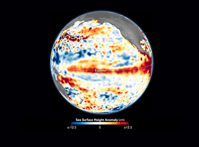
As shown in the map, the data indicate that the sea surface height in the tropical Pacific was over 12.5 centimeters (4.9 inches) higher than average in the first 10 days of June 2023. This implies that this strip of the ocean is warmer than usual because water expands when it's heated.
Warmer waters around the tropic Pacific are a sure sign that El Niño is swinging into action, something which the US National Oceanic and Atmospheric Administration (NOAA) Climate Prediction Center officially declared on June 8, 2023.

What Is El Niño?
The El Niño-Southern Oscillation (ENSO) cycle describes a pattern of climate fluctuations in the Pacific Ocean and its global impact on the world. Every couple of years or so, conditions can flip from El Niño (the "warm phase" of the ENSO) to La Niña (the “cooling phase”).
During El Niño, winds along the equator are weaker. Warm water is pushed back east toward the west coast of the Americas. As a result, less cold water rises toward the surface and the Equatorial Pacific is warmer than usual. An El Niño is declared when sea temperatures in the tropical eastern Pacific rise 0.5°C (0.9°F) above the long-term average.
La Niña is the flip side of the coin, characterized by unusually cold ocean temperatures in the Equatorial Pacific.
The cycle has profound repercussions on weather and climate across the planet, including changes in wind, temperature, and rainfall patterns to the intensity of hurricane seasons and even the distribution of fish in the seas.
In North America, for instance, El Niño conditions are increased rain and snow in Southern California and the Gulf Coast, plus drier-than-usual conditions in the Pacific North-West and parts of the Midwest.
Over in Australia, El Niño typically suppresses rainfall in eastern Australia during the winter and spring months, meaning drier weather and a higher risk of wildfires.
Globally, El Niño years tend to be warmer on average. The big fear is that El Niño conditions could spark a significant number of unprecedented heat waves and push global average temperatures into record-breaking territory.