
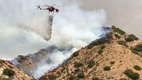


While most Americans were enjoying their long weekend, Los Angeles residents witnessed the largest wildfire in the city's history. A state of emergency was declared and more than 700 Californians living in the area were forced to evacuate their homes.
The fire started in La Tuna Canyon last Friday and by Monday over 7,000 acres had been burned to the ground. Yesterday evening, LA fire officials said the fire is 80 percent contained.
Taking to Twitter, Los Angeles Mayor Eric Garcetti issued a statement on Saturday saying it was the biggest fire in terms of acreage to have ever hit the city. This was later backed up by the Los Angeles Fire Department (LAFD).
“We’re confident, back to 1961, the Bel-Air fire, that this is the largest fire by acreage in the city of Los Angeles,” LAFD Chief Ralph Terrazas on told LA Times on Monday.
It's been a particularly rough year for the Golden State in terms of wildfire. According to CAL FIRE, over 4,900 fires have been reported in 2017 so far. Compared to past years, this is a significant number. Between 2011 and 2015, there was an average of 3,700 fires between January and August.
But California isn't the only state on fire at the moment. As of yesterday, there were 81 active fires reported across California, Colorado, Idaho, Montana, Nevada, Oregon, Utah, Washington, and Wyoming. In Oregon and Washington, hundreds of people have been evacuated and several schools closed due to unhealthy levels of air pollutants.
These two images, captured by NASA satellites on September 4, show the wildfire as it spreads across the West Coast. The areas covered by fire are marked in red. The smoke is shown in white.

Here, you can see the smoke from the West Coast traveling all the way to the East Coast by jet stream. The distance is about 4,800 kilometers (3,000 miles).

For more up-to-date info, The Oregonian and NBC Los Angeles provide real-time data on currently active fires.


