

You’ve probably heard about Beijing’s current “Airpocalypse,” where the air quality over the past few weeks has reached dramatically low levels. Schools have been closed, construction has been stopped, and people have been instructed to stay indoors, especially if they suffer from heart or lung conditions.
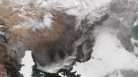
While there have been many images of Beijing taken through a thick veil of smog, perhaps there’s no better way to show the huge scale and spread of smog than by the NASA satellite image above.
This image was captured on November 30, 2015, by NASA’s Visible Infrared Imaging Radiometer Suite (VIIRS) on the Suomi NPP satellite. Since then, the warning has been raised from “orange-alert” to “red-alert” – however, the actual level of pollutants in the air is believed to have peaked on the day this image was taken.
The haze appears to spread from Beijing for hundreds and hundreds of kilometers southwest through the lower plains of China.
The image also gives you further insight into how the mountainous geography is not helping Beijing’s toxic haze. As you can see in the image, Beijing is penned in by the surrounding snow-capped mountain range.
As NASA explains: “Outbreaks of haze like this generally occur during the winter because of temperature inversions. Air normally cools with altitude, but during an inversion warm air settles above a layer of cool air near the surface. The warm air acts like a lid and traps pollutants near the surface, especially in basins and valleys.”