


As reported by British Antarctic Survey (BAS), the tallest mountain in the UK – including its overseas territories – is no longer Mount Jackson. No, it’s not even Ben Nevis, which at the height of 1,345 meters (4,412 feet), is the highest in the British Isles.
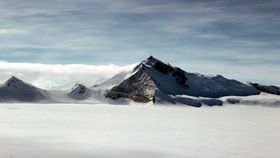
Overseas, Antarctica’s Mount Jackson at 3,184 meters (10,446 feet) was the winner, until now. That accolade suddenly belongs to Mount Hope, also found on the Antarctica peninsula. At a height of 3,239 meters (10,627 feet), it's officially the highest mountain peak in a territory owned by the UK.
So wait – what’s going on here? It’s not like Mount Hope has just been discovered, and although earthquakes can cause mountains to suddenly change height, this isn’t to blame here. In any case, a change of height of 379 meters (1,243 feet) arguably cannot be caused by any natural process. It's not a case of confused nomenclature either.
Funnily enough, the change was made because we are historically awful at measuring mountains. It’s not merely a case of getting the longest slide rule ever and dropping it from the peak all the way down to its sea level base, because that would be most silly and highly impractical.
Traditionally, mountains are measured using a bit of trigonometry. Using a ground-based distance and the angle between the peak and the two points, an estimate would be given.
This, as you can imagine, is not quite as precise with mountains as it is with tiny triangles on a piece of paper. Generally speaking, mountains were measured multiple times using this method, and the height was the average of them all.

Eventually, this technique was superseded – or augmented, really – using satellite technology. As explained over at Live Science, the lines of sight between satellites and communication towers/transponders allow for far more precise measurements of mountain heights.
The curvature and strange oblate spheroid shape of the planet complicates things further, though, which need to be correcting during or after the measurements are made using a variety of algorithms. This means that, in some instances, heights have been underestimated, which is apparently what happened with regards to Mount Hope.
Worried about pilots who may misjudge where the mountain may be in the clouds, cartographers at the BAS decided to reassess the height of the mountains within Britain’s Antarctic quadrant.
First, they used the most up-to-date satellite data, and combined it with digital elevation models (DEMs), which are 3D replicas of the landscape based on the best available data. When it looked as if Mount Hope was indeed higher than Mount Jackson, they created a “pop-up” view of the region using photographs taken from several different angles.
Side by side, it was clear: Hope beats Jackson by around 50 meters (160 feet).


