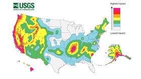


It’s well known that America experiences its fair share of earthquakes, and that California is bracing itself for the so-called “big one,” but few truly appreciate how seismically active the US actually is. Fortunately, the United States Geological Survey (USGS) has on hand a few hazard maps that beautifully illustrate this.
Generally speaking, the redder an area is, the more at risk it is from a severe earthquake.
The unit used by the USGS is a slightly odd one known as “peak ground acceleration”, or PGA. This refers to the acceleration of the ground during an earthquake. It is expressed as a fraction of the acceleration on Earth caused by the planet’s gravitational field.
Essentially, the closer the value is to 1, the more violently the ground is moving. The most powerful, shallow earthquakes will produce the highest PGA values.

These maps are based around a timeline of 50 years. They depict the probability that the PGA values of each area will be matched within each time zone. This one, for example, shows that there is a one-in-10 chance that the San Andreas Fault will experience a 0.4 PGA – a very powerful earthquake – in the next half-century.
This translates to there being a very high risk of an extremely damaging earthquake in the next half-century. A different USGS study describes this in another way – within the next 30 years, an earthquake of 6.7 or above is 99 percent likely to take place in this area.
High PGA values, then, match up to regions of the country where the seismic risk is highest. This risk is high for four different reasons.
Firstly, you have two tectonic plates sliding past each other – for example, the San Andreas Fault, where the Pacific Plate is moving northwards relative to the North American Plate.

Taken from a 2014 study, this map of California illustrates that there is a near-100 percent chance that the San Andreas Fault will rupture to create a 6.7M quake in the next 30 years. USGS
Secondly, every now and then, the continent stretches or rebounds due to seismic activity elsewhere. This pulls apart these old, inactive faults – mantle scars – and “intraplate” earthquakes occur.
On these hazard maps, this mostly represents the red-shaded elliptical zone around Indiana, Tennessee, Oklahoma, Missouri, and Kentucky. This particular region is called the New Madrid Seismic Zone (NMSZ).
The third type of quake is artificially generated by fracking, wherein highly pressurized water is pumped into the ground in order to unleash pockets of natural gas. This behavior is responsible for low-to-moderate seismic events within certain US states, especially Oklahoma.
Finally, along the eastern seaboard, parts of the upper mantle are thinning out and collapsing off into the lower mantle as they age. When more molten mantle material rushes up to fill the new gaps, earthquakes can occur. This was the mechanism behind the 5.8M 2011 quake that shook both North Carolina and Washington DC.