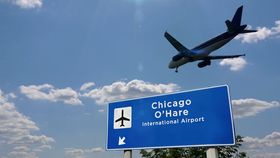


Residents of Chicago experienced an unexpected snow flurry on Sunday evening. The surprise element was down to the lack of major weather systems that would have caused such an event. In fact, the catalysts for the light dusting were airplanes landing and taking off at O’Hare and Midway airports.
In a tweet by the National Weather Service Chicago, the localized snowfall was explained.
Water droplets in the atmosphere do not necessarily freeze at 0°C (32°F). Their purity and spherical shape mean that unlike on the ground, the cloud droplets can be as low as -40°C (-40°F) before freezing into ice crystals. These “supercooled” droplets will remain as a liquid unless their temperature is decreased, or they have something to freeze onto.
Airplane descent can provide both of those conditions. Tiny particles blown from airplane exhaust can provide “nucleation sites”, or “seeds”, for the supercooled droplets to freeze onto. Also, as the plane passes through the clouds, the turbulence created decreases the air pressure around the wings, cooling the cloud droplets enough to form ice crystals.
In Chicago, the low clouds above the city were around -6 to -8°C (21.2 to 17.6°F), made up of the supercooled droplets. As the planes took off from and landed into the two airports, patches of precipitation could be seen in weather maps, but the NWS Chicago reported that the snow was not expected to accumulate from the activity.
According to WREX.com, plane-induced snowfall happens on average four times a year. However, when conditions on the ground are not so cold, a similar type of phenomenon occurs. Commonly known as “hole punch clouds”, when mid-to-high level clouds (such as altocumulus and cirrocumulus) contain supercooled droplets, a freezing process can be triggered by airplane motion. However, instead of the ice crystals forming snowflakes and falling to the ground, they fall as a graceful streak, leaving behind an expanding hole in the cloud layer.

Over a couple of hours, the fallstreak hole, as it is known, can grow to more than 50 kilometers (30 miles) across. This site is most commonly seen around airports. With around 2,400 flights arriving and departing every day from O’Hare Airport, it is no wonder Chicagoans were caught off guard with some plane-induced snowfall.
[H/T: Popular Mechanics]