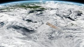


Raikoke Volcano resides on a small, egg-shaped island on Russia’s Kamchatka Peninsula. For nearly a century, the Kuril Islands’ quiet volcano has rested in its isolated environment – a dormant period that came to a close on June 22 much to the chagrin of satellites and astronauts aboard the International Space Station (ISS).
The dramatic eruption was captured around 4am local time on June 21 when a thick plume of brown volcanic ash and gases shot up towards Earth’s atmosphere from its 700-meter-wide (2,300 feet) crater.
“What a spectacular image. It reminds me of the classic Sarychev Peak astronaut photograph of an eruption in the Kurils from about 10 years ago,” said volcanologist Simon Carn in a NASA statement. “The ring of white puffy clouds at the base of the column might be a sign of ambient air being drawn into the column and the condensation of water vapor. Or it could be a rising plume from [the] interaction between magma and seawater because Raikoke is a small island and flows likely entered the water.”
The “unexpected” eruption caused ash plumes to rise to around 13 kilometers (8 miles) above sea levels, with other satellite data analyses indicating it may have reached an altitude of as much as 17 kilometers (10 miles), prompting aircraft advisories in the region. Ash contains fragments of rock and volcanic glass that could pose hazards.

Since its eruption, the plume was pulled into circulation of a storm in the North Pacific and currently is drifting over the Bering Sea, reports the European Space Agency. Satellite sensors track volcanic gases that move through the atmosphere following a volcanic eruption.
“Radiosonde data from the region indicate a tropopause altitude of about 11 kilometers, so altitudes of 13 to 17 kilometers suggest that the eruption cloud is mostly in the stratosphere,” said Carn. “The persistence of large SO2 amounts over the last two days also indicates stratospheric injection.”
It’s believed the volcano last erupted in 1924 and before that 1778.