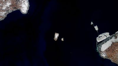


Russia and the US might feel like two places that are worlds apart, but sitting in the middle of the Bering Strait are two tiny islands that prove otherwise. With just 3.8 kilometers (2.4 miles) between them, the Diomede Islands mark the closest point between the two countries.
The rest of this article is behind a paywall. Please sign in or subscribe to access the full content.On the Russian side is Big Diomede, which is just over 10 square kilometers (4 square miles). Historically, it was home to the Iñupiat – as is Little Diomede – but the island now has no permanent population, after its indigenous inhabitants were forcibly relocated to the Russian mainland in 1948. All that remains in the present day is a weather station.
Little Diomede, as the name suggests, is the smaller of the two islands and belongs to the US. It has an area of roughly 7 square kilometers (2.8 square miles) and as of 2021, a population of 82. This small number of residents live in just a single community, called Diomede, which is on the west side of the island, facing toward Russia.

The short gap between the Diomede Islands also plays host to the International Date Line. That means that, despite the fact the distance between the two islands is only about as long as Manhattan Island is wide, the time in Big Diomede is 21 hours ahead of that in Little Diomede. As a result, the two islands have come to bear some very appropriate nicknames: the big one is “Tomorrow Island” and the little one is “Yesterday Island”.
If you fancy indulging in some time travel between the two, you could theoretically also be journeying across the only place where you could walk between the US and Russia. That’s because the waters separating the island freeze over during winter. However, note that we said theoretically – in reality, going between the islands is forbidden.
Traveling between what would later become Russia and Alaska didn’t always require the sea to freeze over, however. Around 25,000 years ago, Earth was experiencing its most recent ice age, and that meant a significant amount of its water was frozen up in glaciers. The result was that sea levels were up to 91 meters (300 feet) lower, and as a consequence, the Diomede Islands wouldn’t have been islands at all – they would’ve been part of a land bridge.
It’s thought that multiple species crossed this link between Asia and North America, including humans – but they would’ve had to negotiate some pretty swampy conditions in order to do so.