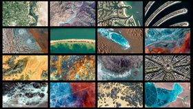
Google Earth has just given you a free pass to explore 1,000 locations on Earth from the comfort of your desk. Taking the Google Earth View collection up to 2,500 landscapes across the globe, the new additions to the gallery prove that there’s an awful lot more to this planet than the animals living on it.
As part of the largest update to the Google Earth View Collection, the recent upload encompasses volcanic regions, desolate seascapes and some scenes so alien it can be hard to even work out what you’re looking at. The images have been optimized to suit 4K screens, bringing some of the most remote spots of the globe to your home in stunning resolution.
I suggest you hold onto your socks.

Flicking through the gallery, it’s hard to believe such aesthetic variety can exist on one planet, and certain scenes, such as the very Mars-like shot of Tabriz, Iran, pictured above, truly seem other-worldly.

"As a species, we've only had access to views from space for the last 50 years," said Gopal Shah, Product Manager for Google Earth in a Google blog. "Yet something encoded in us long ago seems to wake up when we see the world at this unprecedented scale. My hope then is this funny, little project – along with Google Earth as a whole – moves us to care more deeply about this strange but kaleidoscopically beautiful planet."

The gallery has been extended to include a color map for locating the thousands of Earth View snaps, and the images, which are available to download, can be used as wallpapers on Android and as screensavers for Chromecast and Google Home.

One particularly arresting shot is the above of the Grand Prismatic Spring in Yellowstone National Park, which is the largest hot spring in the United States, and the third largest in the world. The bizarre array of colors seen in the spring are the result of “microbial mats,” which form sheets of differing microbes around the edges of the mineral-rich water.

There's so much to see on Google Earth and Google Maps it can feel almost overwhelming – but fear not. Someone already took the time to track down the greatest thing on Google maps.