

You probably associate GIFs with Reddit and obscure pop culture references. However, this hilarious and mesmerizing medium is now being used by geographers to document the movement of glaciers.
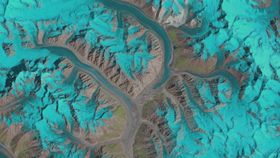
These GIFS are from a recent study by the University of Zurich looking at the dynamics of glacier flows in the Karakoram mountain range in Asia. Over a span of 25 years, the study used three different satellites, operated by the U.S. Geological Survey (USGS) and NASA, to document the shifting movement and advances of glaciers. Glacier changes during that time period were then compressed into one second.
The Skamri region. Image credit: Frank Paul, University of Zurich
The study looked at the areas of Baltoro, Panmah, Skamri-Sarpo Laggo, and Shaksgam; four regions known for their “surge glaciers.” The study is believed to be the most expansive, in terms of both time and size, visual documentation of glacier movements ever.
The images reveal that the Karakoram glaciers are either stable or advancing. This is an optimistic boost for glaciologists, who have seen many of the Earth’s glaciers struggling to cope with increasing temperatures.
Frank Paul, who lead the study, told phys.org: "From a scientific point of view, the key motivation for this research was to understand the highly variable behaviour of the glaciers in the Karakoram. We have known about this for over 50 years, but still have a very limited scientific understanding of what is going on there. The animations are a very practical way to get a better overview and follow the changes through time."
Baltoro region. Image credit: Frank Paul, University of Zurich