

Some 10,000 to 20,000 years ago, cataclysmic floods of water tore through a portion of North America now known as Washington State. Incredibly, the scars gouged into the earth from this violent event can still be seen today, revealed by satellite images from space.
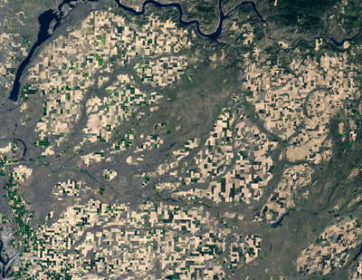
As explained by NASA Earth Observatory, these satellite images were captured back in May 2023 by Landsat 8, an Earth observation satellite under the command of NASA and the United States Geological Survey (USGS) that orbits our planet every 99 minutes.
They show a portion of southeastern Washington State called the Columbia Plateau that’s abundant in agricultural land growing hops, tree fruit, sweetcorn, milk, potatoes, grains, and many other vegetables.
Carving across patches of green and brown farmland, the images reveal the giant gray streaks known as the Channeled Scablands. From ground level, these features appear as huge rocky formations, made up of steep-sided canyon walls and jagged cliffs.

The formations were a long-standing mystery for geologists until the 1920s when a high school science teacher named Harley Bretz theorized that they could have been sculpted by glacial streams.
“The channeled scablands are the erosive record of large, high-gradient, glacier-born streams,” he wrote in his 1923 research paper. “The magnitude of the erosive changes wrought by these glacial streams is nothing short of amazing."
While controversial at the time, his theory turned out to be on the money. Scientists now know that the Channeled Scablands were formed during the Ice Age due to a huge ice dam that formed along the Clark Fork River. Behind the ice dam, water from the Clark Fork gathered.

Over several thousand years, the ice dam continuously broke and reformed, flooding the plains with 2,100 cubic kilometers (500 cubic miles) of water traveling at over 128 kilometers (80 miles) per hour. According to National Geographic, this torrent of water had the force of 10 times the combined flow of all the world's rivers, so it’s not hard to see how it carved these vast geological features.
One of these sights is Dry Falls, once the greatest known waterfall that ever existed on Earth. Now, however, it’s just a 121-meter-high (400-foot), 5.6-kilometer-wide (3.5 miles) cliff that overlooks a gaping gorge and a set of lakes.
While the landscape is perhaps more picturesque from ground level, its epic scale can be best appreciated from a satellite cruising 705 kilometers (438 miles) above Earth.