The amount of ice at the poles and in glaciers around the world has shrunk dramatically over the last few decades due to climate change. The ice loss will become more and more prominent as temperatures continue to rise but to accurately predict the specific changes we need precise data.
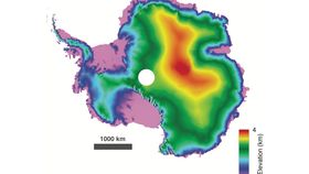
With that in mind, researchers from the University of Edinburgh wondered if they could improve on the data collected by the European Space Agency’s satellite CryoSat. They were able to reprocess observations collected since 2010 and dramatically improve the resolution, delivering CryoSat's sharpest 3D map of Antarctica yet.
The results were presented this week at the Living Planet Symposium in Milan, Italy. CryoSat carries a radar altimeter that is used to measure the height of the world’s ice. The satellite sends a microwave pulse and times how long it takes for the pulse to bounce off the ice and come back to the satellite. Differences in return time correspond to precise differences in altitude.
While the approach has been very useful for imaging the vast icy expanse of the southernmost continent, it doesn’t deliver very detailed results regarding Antarctica's terrain. The data analysis conducted so far has focused on the first data point coming back to the craft so it might be missing the finer details of ground formation.
The research team used an approach called “swath processing”, which takes into account all the data coming from the microwave pulse. By employing this technique, they were able to reduce the spatial resolution on the surface to less than 1 kilometer (0.6 miles). This allowed the production of the excellent 3D map, which gives precise altitudes and quite detailed information on geographical formation.
There is a lot of interest in producing detailed maps of Antarctica. Just last year, the best terrain map of the continent was released by researchers. The map is actually so good that it is the best map of a continent ever made.
Antarctica remains an unexplored and somewhat mysterious part of the world but its wellbeing is crucial to us. If all of the ice covering Antarctica melted, global sea level would rise by a worrying 70 meters (230 feet).
[H/T: BBC News]