

After embarking on a mammoth journey from Africa across the Atlantic last week, a gigantic plume of Saharan dust is now brushing over the Caribbean and settling in towards its final destination in the US.
The National Weather Service reported on Wednesday, June 24, that the Saharan Air Layer dust plume has covered the Caribbean region and most of the Gulf of Mexico. On June 24 and 25, it's forecasted to drift upwards towards North America where it will mainly affect Texas, Alabama, Mississippi, Louisiana, Florida, and a number of other southern states towards the end of the week. By the start of next week, the skies should be more or less back to normal.
If you’re in this neck of the woods, you can expect to see hazy skies during the day, along with stunning sunrises and sunsets. It’s already provided some pretty impressive sights that have been captured by satellites, astronauts, and Earth-bound humans alike.
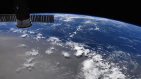
Colonel Doug Hurley, who is currently onboard the International Space Station, tweeted a photograph (image above) of the Saharan dust plume on June 21 over the west-central Atlantic and said: "amazing how large an area it covers!"
However, it isn’t all good news. People with existing respiratory conditions should also be wary as the plume of dust may exacerbate some respiratory and cardiac problems.
So, what’s a colossal cloud of dust from Africa’s Sahara Desert doing in the Western Hemisphere anyway?
It’s all to do with the Saharan Air Layer, a layer of baking hot and dry air in the atmosphere that travels around 10 to 25 meters per second (33 to 82 feet) above the cooler surface air of the Atlantic Ocean. The Saharan Air Layer typically fires up its activity in mid-June, often bringing with it a bunch of desert sand and peaks over the course of the summer.
Joe Prospero, a professor emeritus of atmospheric science at the University of Miami, told the Washington Post this week that the US could see the most significant amount of Saharan dust in the air since the 1970s. He added that “this event is comparable to, or exceeds, the most extreme events in the past.”
The Saharan Air Layer also tends to reduce hurricane activity, which should provide some respite from the ongoing Atlantic Hurricane Season and wet weather.
Perhaps most remarkably of all, the Saharan Air Layer is known to deliver much-needed phosphorus, potassium, and calcium to the Amazon rainforest, effectively acting as a fertilizer that feeds the growth of the jungle. Some gardeners also swear a gust of Saharan dust is good for their flowers, although that’s not scientifically proven.