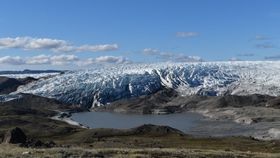


An enormous ancient lake bed has been discovered deep beneath the Greenland ice sheet that could be millions of years old, according to a study published in Earth and Planetary Science Letters. The fossil bed may contain a wealth of preserved information on what the country looked like all those years ago, but is buried beneath one of the most inhospitable landscapes on the planet.
The Greenland Ice sheet is a vast body of ice that makes up around 79 percent of Greenland’s area, covering ~1,710,000 square kilometers (660,234 square miles) in total and reaching 3.2 kilometers (2 miles) deep. Beneath the ice lies a bounty of potential data on past environmental conditions but accessing its treasures is a difficult feat.
By using modern radar technology, what lies underneath the ice can now be mapped by scientists. By flying over Greenland and utilizing radar, gravity and magnetic data provided by NASA, the scientists identified the remains of an ancient lake that extended 7,100 square kilometers (2,741 square miles). Once holding a huge amount of water drained from the surrounding basin, the lake dried up and left behind a 1.2-kilometer (0.7miles) deep bed of sediment, sealed in by ice. This is the first time this kind of sub-glacial feature has been discovered.

According to the researchers, for sediment to build in such a substantial way, there must have been long periods of ice-free conditions. Drilling down to reach the sediment for analysis could tell us more about the pattern of ice melting that occurred so long ago. Sediment such as this can contain a variety of materials that can show us the climate at the time of settling, and even data on the local fauna.
“If we could get at those sediments, they could tell us when the ice was present or absent,” said Guy Paxman, a postdoctoral researcher at Columbia University’s Lamont-Doherty Earth Observatory and lead author of the report, in a statement.
Exactly how old the lake bed is remains a mystery. Researchers believe it could be as old as 30 million years, or it could be within a few hundred thousand years ago and be the result of repeated covering and uncovering due to varying climate conditions.
This isn’t the first time researchers have discovered geographical formations beneath the ice. In 2019, 54 candidates for subglacial lakes, containing large bodies of water trapped under the ice sheet, were identified in Greenland.
The team now hopes to drill into the sediment to discover what lies in the lake bed, but it may not happen soon. Drilling deep into the ice sheet is a huge undertaking, the last large ice core drilling in Greenland took place in the 1990s and has not been repeated since. A new project is planned to take place soon, but it is in a different region to the ancient lake that is significantly more shallow.
Understanding the past climate can help us further understand how it may change in the future, and how the ice sheet may behave in the coming years. Climate change is an issue that affects every area of the globe, and gathering data on past trends is vital for attempts to mitigate it going forwards.
“We’re working to try and understand how the Greenland ice sheet has behaved in the past. It’s important if we want to understand how it will behave in future decades,” said Paxman.