

Hurricane Sam is the strongest storm of the 2021 Atlantic storm season so far. Luckily, it is out to sea with no scheduled landfall – but that doesn't mean we can't experience the ferocious winds and waves from inside the belly of the beast from the safety of our own homes. In a world-first, a very hardy drone ship set sail for Sam and captured the first wild footage from inside a category 4 storm, which you can see right here.
The video shows what Saildrone Inc and NOAA describe as "the first video footage gathered by an uncrewed surface vehicle (USV) from inside a major hurricane barreling across the Atlantic Ocean." It reveals heaving 15-meter (50-foot) waves at quite stomach-churning angles and 193 kilometer per hour (120+ mile per hour) winds, so if you get seasick approach with caution.
The Saildrone Explorer SD 1045 is one of five USVs Saildrone deployed from the Virgin Islands in August in partnership with NOAA to gather data throughout this year's Atlantic storm season.
Specially designed "hurricane wings" help the USVs operate in extreme conditions, including 112 kilometers per hour (70 miles per hour) winds and waves over 3 meters (10 feet) high – which is good, because they were programmed to sail directly into the path of hurricanes.

Tropical Storm Sam, the 18th named storm of the season, formed on September 23 before becoming a hurricane on September 24, reaching category 4 status by September 25. By this time, the record-breaking 2020 season had more named storms, at 23. However, there are still another two months of the season to go to see if 2021 will reach 2020's total of 30.
Saildrone shared another video that shows SD 1045's location in the hurricane alongside the footage.
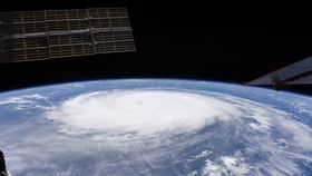
Satellite imagery of hurricanes churning from orbit is pretty common these days as they are monitored from all angles. Footage from ocean level on the other hand is new, collecting critical scientific data whilst also giving us a completely new view of one of Earth's greatest – and most destructive – phenomena.
“Saildrone is going where no research vessel has ever ventured, sailing right into the eye of the hurricane, gathering data that will transform our understanding of these powerful storms,” said Richard Jenkins, Saildrone founder and CEO, in a statement.
“Using data collected by saildrones, we expect to improve forecast models that predict rapid intensification of hurricanes,” added NOAA scientist Greg Foltz. “Rapid intensification, when hurricane winds strengthen in a matter of hours, is a serious threat to coastal communities. New data from saildrones and other uncrewed systems that NOAA is using will help us better predict the forces that drive hurricanes and be able to warn communities earlier.”
The National Hurricane Center expects Sam to remain a hurricane status for the next few days, and is likely to send some huge swells towards islands like Bermuda and the Bahamas. "These swells will likely cause life-threatening surf and rip current conditions," NOAA warned, so stay well away from the seas in these areas for the next week. Sit back and watch the wild weather from the comfort of your sofa instead.