Hurricane force winds, heavy snow, and flooding whacked the central United States last week, leaving thousands without electricity and stranding hundreds of drivers. The winter storm has already barreled over the Central Rockies, the Plains, and into the Mississippi Valley, with 75 people and two dogs rescued in Colorado on Wednesday, and at least two deaths.
So what is a “bombogenesis” otherwise known as a “bomb cyclone”? It is not a bomb in the fiery sense of the word. Instead, a bomb cyclone is a sudden drop in atmosphere pressure, leading to a mid-latitude cyclone that “explosively” intensifies in a short amount of time. Specifically, barometric pressure rapidly drops by 24 millibars or more within 24 hours.
"The term bomb cyclone essentially applies to the deepening rate of the surface pressure, generally 1 millibar over a 24 hour period – what’s interesting about this event earlier in the week is that rapid intensification occurred in about half the time. In about 12 hours, the bomb dropped somewhere on the order of 24-27 millibars," said Greg Carbin, chief of the Forecast Operations Branch at NOAA's Weather Prediction Center in College Park, Maryland.
"The rapid development of the cyclone is impressive but not all that unusual," added Carbin. "The low pressure is what's interesting. Pueblo, Colorado, broke their prior station record that was set in 1950 with the storm, so that bit was pretty unusual."
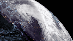
The satellite images of tufts of white swirling over Earth may be mesmerizing to watch, but it is causing fierce weather below. The National Oceanic and Atmospheric Administration (NOAA) posted a series of shots of the event, calling it “a rare one for the landlocked region.”
Although a "bombogenesis" is not as scary as it sounds, it can be dangerous, with travel conditions particularly affected.
“When you watch those satellite loops of the development of the cyclone, you see this sort of broad, almost raw shield of cloudiness and moisture that’s being lifted up in the atmosphere and then ejected out, essentially at very high levels of the atmosphere where the jet stream is. You’re seeing a number of processes taking place at once,' said Carbin.
Check out some of the satellite images below.
The geostationary lightning mapper (GLM) is a near-infrared optical transient detector on the GOES-16 satellite. The GLM allows NOAA to detect lightning at rates never previously caught before, from space. “Scientists can now study the electrosphere over dimensions ranging from the Earth's radius all the way down to individual thunderstorms,” they note.
"There was a cyclone on March 13, 1993, dubbed the storm of the century in the eastern United States," said Carbin. "Exactly the same day, 26 years ago, and 1,500 miles to the east, you had a very similar event occur in the atmosphere."