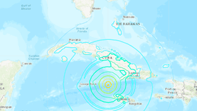
Caribbean nations are still rocking into the evening on Wednesday after a magnitude 7.7 earthquake was reported in the Caribbean Sea between Jamaica and Cuba this morning, the US Geological Survey (USGS) reports.
The epicenter of the first quake was located 10 kilometers (6 miles) deep and 125 kilometers (77 miles) northwest of Lucea, Jamaica. The National Tsunami Warning Center issued a statement at the time, noting that earthquakes of this size are “known to generate tsunamis dangerous to shorelines near the source,” but that there was no danger for the US east coast or the Gulf of Mexico. Any tsunami threat to the region has now passed, according to NOAA.
Several additional earthquakes have shaken the region in the hours following the earthquake, including a 4.5 and 4.9 magnitude tremor located 71 kilometers (44 miles) southeast of the Cayman Islands and a 4.7 magnitude quake northwest of Lucea, the USGS reports. Experts report that the first earthquake was the result of strike-slip faulting between the North America and Caribbean tectonic plates. Strike-strip faults are vertical fractures that mostly move horizontally – those that occur on a fault on which two blocks slide past each other, one of the most well-known being the San Andreas Fault in Southern California.
Throughout the day, shaking has been reported in parts of far western Jamaica that is capable of causing moderate to heavy damage. Moderate shaking on Grand Cayman Island and light shaking on Mexico’s Yucatan Peninsula to the west was also reported. The effects were felt as far north as Florida, where buildings in downtown Miami shook as a result of the earthquake, prompting some evacuations throughout the city, the Miami Herald reports.
It comes after neighboring Puerto Rico continues to tremble amid ongoing fatal and devastating seismic activity for nearly a month. Most recently, the US island territory experienced a 5.0 magnitude earthquake near the epicenters of other recent quakes. Earthquakes are not uncommon for the region, but AccuWeather notes that most measure less than a 3.0 magnitude.
“Five other earthquakes of M 6 or larger have occurred within 400 km of the January 28, 2020 event over the preceding century. These include a M 6.8 earthquake in December 2004, 280 km to the west of today’s earthquake, and an M 6.2 event in May 1992, almost 100 km to the east of today’s quake,” notes the USGS, adding that it is likely because of their location away from land and major populations that none of the previous earthquakes caused damage or fatalities.
It is not yet known whether the earthquake caused extensive damage or injuries, but social media posts show the earthquake shaking buildings and infrastructure.