


California's severe drought doesn’t simply affect people’s access to water, it can also have severe geological consequences. This includes the subsidence of the San Joaquin Valley. As people use the groundwater, the valley continues to sink into the ground.
The region has sunk up to 8.5 meters (28 feet) since the 1920s, and California’s Department of Water Resources (DWR) has commissioned NASA’s Jet Propulsion Laboratory to use satellite radar data to establish the extent of the land subsidence. The initial report has now been published.
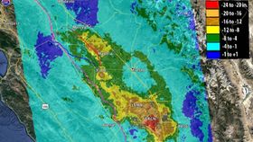
Between May 2015 and September 2016, the area of Corcoran sank almost 0.6 meters (2 feet). Significant subsidence was also recorded in Fresno county and near Chowchilla. These rapid changes are worrying as they can affect aqueducts, flood defenses, and roads.
“The rates of San Joaquin Valley subsidence documented since 2014 by NASA are troubling and unsustainable,” said DWR Director William Croyle in a statement. “Subsidence has long plagued certain regions of California. But the current rates jeopardize infrastructure serving millions of people. Groundwater pumping now puts at risk the very system that brings water to the San Joaquin Valley. The situation is untenable.”
California in general and this region in particular are some of the most productive agricultural regions of the United States. However, the drought has led farmers to rely heavily on groundwater, which has, unfortunately, made the sinking worse.
As the report explains, the groundwater reservoirs can refill naturally as long as they are not pumped too low. When too much groundwater is extracted, this leads to irreversible changes and permanent subsidence. Rain can help slow the process, but there has not been a sufficient amount to replenish the reservoirs.
“While we can see the effect that rain has on subsidence, we know that we’ve run a groundwater deficit for some time, so it’ll take a long time to refill those reservoirs,” said JPL report co-author Tom Farr.
Co-author Cathleen Jones added: “If you see a subsidence bowl, then something is going on at the center of the bowl that is causing the land to sink; for example, high levels of groundwater pumping. We can locate problem spots so the state can focus on those areas, saving money and resources. We find the needle in the haystack, so to speak.”
New upcoming missions from NASA will help monitor these changes more precisely and also provide officials with the effectiveness of natural and assisted groundwater recharge.


