Two sets of satellite images captured by NASA’s Earth Observatory show the extent of flooding in parts of North Carolina, and just how much debris is being carried through the tar heel state’s swollen waterways.
Landsat 8, a satellite operated jointly by NASA and the US Geological Survey, scoped out residential areas and rivers from space after Hurricane Florence dumped an estimated 8 trillion gallons of rain between September 13 and 17, according to the National Weather Service in Raleigh.
The first set of images snapped by the Operational Land Imager (OLI) reveal extensive flooding in several residential areas and along major rivers near the small town of Trenton, which runs along the Trent River. The first image shows the Trent River, visible as a faint squiggly line, on July 14, 2017.


Using a combination of visible and infrared lights to distinguish between flood waters, the second false-colored image highlights changes in the river and groundwater on September 19, 2018. Two days before, the river here swelled to an all-time high of 8.8 meters (29 feet), double the river’s flood stage – the minimum height of overflowing before it causes damage. The last time the river was remotely near this height was more than 10 years ago, according to the National Weather Service. The river dropped to 7.3 meters (24 feet) by September 20, but nearly the entire town of Trenton is still flooded, with many homes, buildings, and roads still full with standing water.
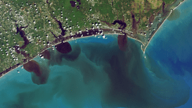
The second set of images show how flooding has affected water quality in three North Carolina water systems – the White Oak, New River, and Adams Creek. Captured on September 20, 2018, the first shows how soils, sediment, decaying leaves, pollution, and other debris has discolored waters flowing out to the Atlantic Ocean.
A second image shows the amount of colored dissolved matter (CDOM) in these places, which include leaves, roots, bark, and other organic materials that contain pigments, such as tannins. As these pigments naturally break down and dissolve, they turn the water shades of blue, green, yellow, and brown.

In other eastern states, pollution by way of flooding continues to be an issue as Superfund cleanup sites, hog waste lagoons, coal ash facilities, and power plants were flooded when Hurricane Florence made landfall and the days that followed – not to mention the millions of chickens and hogs found dead and floating through floodwaters or the thousands of fish strewn about local roadways.
Florence was the first major hurricane in the 2018 season and the second wettest tropical cyclone ever in the contiguous US following Harvey in 2017. Dozens of deaths have been attributed to the storm, and it is estimated to have accrued between $17 and $22 billion in property damage.