

Since early May this year, satellites have been tracking volcanic activity in a deep-sea basin, just north of Papua New Guinea, which could give birth to a new island.
The rest of this article is behind a paywall. Please sign in or subscribe to access the full content.You’ve probably heard that we know more about the surface of the Moon than we do the deep-ocean floor. Well, that certainly seems true in this instance.
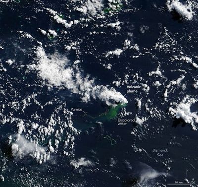
On May 8, seismometers detected a collection of earthquakes occurring in a deep-sea basin in the central Bismarck Sea. Soon after, satellites captured evidence of a submarine eruption taking place. However, scientists quickly realized they had no idea what was actually down there.
There were no high-resolution maps of the area, meaning they didn't know much about the complex seafloor containing faults, volcanic features, rifts, scarps, and active subduction and spreading zones.
From what they could make out in the satellite images, it looks like the eruption took place along the Titan Ridge. This is at the junction between two submarine plates. But there is little clarity on which volcanic feature was responsible, at what depth the active vent was before this event, or when it erupted last.
Despite these unknowns, there's still a lot to learn from this eruption.
"The good news is that there are huge opportunities to explore and learn using both government and commercial satellite platforms already in orbit," Jim Garvin, the chief scientist at NASA's Goddard Space Flight Center explained in a statement.
On May 9, NASA’s Aqua and Terra satellites, which monitor the climate, weather, and environmental changes on Earth, recorded images of white, steaming volcanic plumes issuing from the water’s surface. Other satellites showed that these plumes extended several kilometers into the atmosphere.
At the same time, the PACE satellite observed discolored and disturbed water around the eruption site.
But by May 10 and 11, the volcanic activity had moved closer to the water’s surface. This was captured in higher-resolution images from the European Space Agency’s Sentinel-2 satellite and the NASA/USGS Landsat 9 satellites.
Then, on May 12, thermal anomalies covering around 7 square kilometers (2.7 square miles) were detected using the infrared cameras on the Suomi NPP satellite, which usually tracks long-term climate change and short-term weather conditions.
"There must be a lot of hot material near the surface to generate so many thermal anomalies," Simon Carn, a volcanologist at Michigan Tech added.
"This suggests a fairly shallow eruption vent – much shallower than what's implied by the existing bathymetry, which shows water depths of several hundred meters or more."
Scientists have also seen expansive pumice rafts – porous, floating volcanic rocks – accumulating in long bands in the surface currents.
"We're now eagerly waiting to see if a new island is about to be born – something that we've only rarely been able to observe with satellites as it happens," Garvin stated.
This is an exciting opportunity for volcanologists. If a new island does emerge, they will be watching to see how it evolves. It could become a tuff cone – a steep, bowl-shaped volcano formed when magma makes contact with water – that has a long life, or it could simply collapse and erode away.
Alternatively, the eruption could become more explosive if seawater finds its way into the shallow magma chamber that’s risen with the emerging underwater structure.
This new event’s comparative gentleness may be because it’s associated with a volcanic ridge that sits at the junction of a transform fault, where two tectonic plates meet and slide past one another, and a back-arc spreading center, which is a common feature of submarine volcanoes.
"Spreading centers are associated with less explosive activity, while the most explosive eruptions are usually along subduction zones and involve large stratovolcanoes", Carn explained.
It's currently unclear how long this new activity will last. An eruption along the same ridge in 1972 lasted only four days, while another that occurred in 1957 in the St. Andrew Strait, around 100 kilometers (62 miles) away, lasted about four years.
Garvin and colleagues will be monitoring events closely.
If a new island does form, it could offer a chance for researchers to study how plants and animals colonize the infant island. They could also monitor the effects of rainfall, chemical weathering, and other erosive forces as the island progresses.
"This new eruption could present an even better opportunity for 'island-naut' exploration as we prepare to return to the Moon with women and men via Artemis IV," Garvin said.