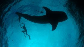


Just off the shores of Indonesia, scientists are live-tracking the movement of the world's biggest fish: whale sharks. Best of all, you can see this satellite data, showing the whale sharks' movement on a map in near real-time.
The expedition began last year in the Bird’s Head region of eastern Indonesia, where researchers from Conservation International attached tags to 16 of these 12-meter-long (40 feet) benign beasts. It's become one of the most successful whale shark mapping projects ever, but the methods they used were surprisingly unorthodox. Instead of actively hunting them down, the researchers dived into waters where fishing nets had accidently caught the whale sharks. By an odd coincidence, which continues to baffle the scientists, all of the caught whale sharks were adolescent males.
On Monday, June 27, the scientists started their live-tracking of the whale sharks using satellites. You can watch the live map of the whale sharks' movement below. Although, understandably, they noted that there will be an undisclosed delay to the data to prevent any potential threat from poachers.
Map created by Conservation International.
The data has already shed light on the lesser-known behavior of this marine species. For example, one whale shark reached a depth of 1,808 meters (nearly 6,000 feet) – considerably deeper than previously thought.
Another surprise was how far this species travel. It was previously assumed these juggernauts stay in their known stomping grounds, however they were recorded traveling distances of more than 1,300 kilometers (800 miles) – as far away as the Philippines, Papua New Guinea, and the southern Mariana Trench – and then returning to their bay.
Head over to the Conservation International website for more information on this project.
In the meanwhile, check out some of the stunning photography from the research expedition.

Image credit: Shawn Heinrichs

Image credit: Burt Jones and Maurine Shimlock

Image credit: Shawn Heinrichs