Two volcanic islands were born in the Red Sea between Africa and Asia after two explosive eruptions that took place between 2011 and 2013, according to findings published in Nature Communications this week.
How volcanic islands form isn’t well understood, especially those that emerge in underwater ridges where the seafloor is spreading; these events are very rare, and only a few have been witnessed. Thanks to high-resolution optical satellite images, a trio of researchers from King Abdullah University of Science and Technology, led by Sigurjón Jónsson, were able to examine the birth and development of two new islands in the Zubair archipelago – a group of 10 volcanic isles and several rocks in the southern Red Sea between Yemen and Eritrea.
Both new islands were created by magma squirting up along north–south fractures under the seafloor, according to Jónsson's team. The two grew rapidly during the initial eruptive phases as they were fed by two fractures filled with magma known as dykes.
 Sholan Island in the north emerged shortly after Yemeni fishermen reported an eruption on December 18, 2011. You can see a satellite photo taken on December 23, 2011 of that island-creating eruption. The first of the earthquake swarms were detected in April of that year and two earthquakes (magnitudes 3.7 and 3.9) were felt just a few days before. The island continued to grow until the eruption ended on January 12, 2012. At its biggest, Sholan Island was 0.52 kilometers wide and 0.77 kilometers long.
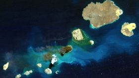
Another submarine eruption began on September 28, 2013, and Jadid Island surfaced in October of that year (pictured above). It was about eight kilometers southeast of Sholan. The first of these earthquake swarms were detected nearly a year prior, and six earthquakes were felt just two days before the eruption – which lasted for 54 days. The circular-shaped Jadid Island grew to a diameter of 0.9 kilometers.
When the team modeled the ground deformation observed on the neighboring islands, they estimated that the dykes were at least 10 kilometers long – much longer than the size of the islands might suggest. Within months and for years afterwards, wind and coastal erosion (including landslides) modified the shape and size of the islands. But despite being weathered away, the islands will probably remain above water.
Magma intrusions along mid-ocean ridge systems are often overlooked when there’s no evidence on the surface. These findings reveal that the Zubair archipelago is far more geologically active than we previously thought. Half a dozen seismic swarms have been recorded in the last two decades: while the 2011 and 2013 swarms were followed by eruptions within a year, the significance of most of the others went largely underestimated until now.
Images: Jónsson et al. / Nature Communications