
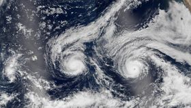


It is now peak hurricane season in the Atlantic and Pacific Oceans, which this year features a meteorological first. Not one, but two tropical cyclones are barreling towards Hawaii at the same time, something that has never happened before. Simultaneously, another brews off the coast of Florida.
The two Pacific monsters, named Madeline and Lester, have – or at least, had – the potential to cause significant damage to the state of Hawaii.
Just before Madeline was about to hit Hawaii, Governor David Ige signed an emergency proclamation, while urging Big Island residents to take immediate steps to protect their families, employees, and property. According to ABC News, a dozen schools are to be used as emergency shelters, and public schools and universities will be closed until at least Friday. Ports and harbors will also be closed until the storms subside.
As of August 30, 11pm Hawaiian Standard Time (August 31, 10am BST), Madeline touched the side of Big Island. Earlier that day, it had sustained winds of about 193 kilometers per hour (120 miles per hour), which would make it a category 3 hurricane, but quickly lost energy and dropped down to a category 2.
By the time it impacted Hawaii, it was a less frightening category 1, and it is projected to turn into a tropical storm within the next few hours. The extent of the damage is not yet clear.
Hurricane Lester, however, is further east, and careening westwards. As of the same time, 11pm Hawaiian Standard Time (10am BST), it has sustained winds of 225 kilometers per hour (140 miles per hour), which currently makes it a category 4 hurricane. Fortunately, modeling predicts that it may just miss Big Island, and by Saturday local time, it will be a mere category 1.
Meanwhile, in the Atlantic, Hurricane Gaston is churning away, although it’s still quite far from the eastern seaboard. According to the tracking maps, Hurricane Gaston is currently a category 3 hurricane. Fortunately, it is likely to die in the Atlantic Ocean – models show it is moving eastwards, and by Saturday morning it will be a lowly tropical storm.

Hurricane Gaston. NASA
Hurricanes making landfall are rare in Hawaii, as they historically tend to form further north or south. The fact that two are streaking towards the island state at the same time is truly unprecedented, although back-to-back hurricanes hitting other regions is actually not unusual as of late.
“Usually the waters [along this storm track] are on the edge of what’s needed to support hurricanes,” meteorologist Bob Heston told Gizmodo. “Now, they’re just warm enough, and it’s making a big difference.” Although long-term oceanic warming is partly to blame, regionally stable atmospheric conditions, those that are just perfect for sustaining powerful hurricanes, are also culpable here.
Hurricanes are essentially heat engines, powered by the warmth of the sea surface. Thanks to human actions, sea-surface temperatures are reaching unprecedented highs, and as a result, many have expected hurricanes to become more powerful over time.
A recent study has explained why this effect hasn’t yet been conclusively seen, while going on to add that in the near-to-immediate future, it will be. Ultimately, there will be less hurricanes in the future, but they will individually be more powerful than anything humanity has ever seen.
Regardless, hurricanes are already remarkable forces of nature. In fact, the average hurricane produces energy equivalent to 600 million lightning strikes per second, or 2.2 trillion strikes per hour, based on information given by the National Oceanic and Atmospheric Administration (NOAA) – most of which is invested in generating heavy rainfall, not the powerful winds hurricanes are normally associated with.

Hawaii has braced for impact. behindlens/Shutterstock


