Radar technology is not just for tracking aircraft – it can also be used to take a number of astronomical measurements, from the rotation of Venus to incredible images of objects in space. One of these pictures was released earlier this year, and as the technology progresses, new views are coming out.
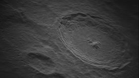
The latest is a 1.4-billion-pixel view of Tycho Crater, a prominent feature of the near-side of the Moon located in the Southern lunar highlands. The image covers an area of 200 by 175 kilometers (124 by 108 miles), fitting the full size of Tycho that stretches for 86 kilometers (53 miles). The image reaches a resolution of 5 by 5 meters (16.4 by 16.4 feet), the highest ever achieved for images of our Moon.
The incredible image was possible using the Green Bank Telescope (GBT) and a technology called Synthetic Aperture Radar (SAR). The radio telescope, the largest fully-steerable globally, sends signals that bounce off the Moon’s surface and come back down on Earth when they are received, stored, and analyzed into a full image.
“This is the largest synthetic aperture radar image we have produced to date with the help of our partners at Raytheon,” Dr Tony Beasley, Director of the National Radio Astronomy Observatory, and vice president for Radio Astronomy at Associated Universities, Inc. said in a statement. “While more work lies ahead to improve these images, we’re excited to share this incredible image with the public, and look forward to sharing more images from this project in the near future.”
The project has just received extra funding for a significant extension. The team hopes to demonstrate that this groundbreaking work can do even more of what they have demonstrated so far.
“Radar data like this has never been recorded before at this distance or resolution,” added Galen Watts, an engineer at the Green Bank Observatory. “This has been done before at distances of a few hundred km, but not on the hundreds of thousands of kilometers scales of this project, and not with the high resolutions of a meter or so at these distances. It all takes a lot of computing hours. Ten or so years ago it would have taken months of computing to get one of the images from one receiver, and maybe a year or more from more than one.”
This approach could one day be used to create radio maps of much more distant worlds, like moons of the gas giants. Also, the image from Tycho is only the first in many others that will be released in the next few months.