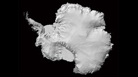


Understanding how we affect the natural world requires knowledge of what has changed over time. For this reason, researchers have come up with the Reference Elevation Model of Antarctica (REMA), the most detailed high-resolution map of Antarctica ever created. In fact, it's so good that it is actually the best terrain map of a continent ever made.
The rest of this article is behind a paywall. Please sign in or subscribe to access the full content.The map has a resolution of 8 meters (26 feet), although in certain places this goes all the way down to an incredible 2 meters (6.5 feet). Previous maps have typically had a resolution of 1,000 meters (3,280 feet), so the jump in quality is significant. The map also has timestamps, which will allow researchers to monitor changes, even very small ones.
“It is the highest-resolution terrain map by far of any continent,” project leader Professor Ian Howat, from The Ohio State University, said in a statement. “Up until now, we’ve had a better map of Mars than we’ve had of Antarctica. Now it is the best-mapped continent.”
The high-resolution map was possible thanks to images taken by a constellation of satellites in polar orbit. Each region has been observed up to 10 times. Data from the project comes from images taken as early as 2009 and as recently as 2017, during the austral summer (mostly December to March). The first version currently available includes 98 percent of Antarctica's contiguous continental landmass. The final map has a total file size of 150 terabytes.

“At this resolution, you can see almost everything. We can actually see variations in the snow in some places. We will be able to measure changes in the surface of the continent over time,” Howat added. “We will see changes in snow cover, changes in the motion of ice, we will be able to monitor river discharge, flooding and volcanoes. We will be able to see the thinning of glaciers.”
The map – which will continue to be updated – is so precise that it will allow teams of scientists to undertake missions in difficult-to-access regions whose terrain conditions were previously unknown. It will become an important instrument for not only exploring the icy continent but also helping us preserve it.