
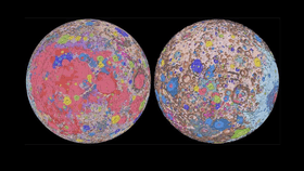


For the first time, a collaborative team of space scientists has completely mapped the geology and surface of the Moon now providing a “seamless” and “globally consistent” picture of our satellite throughout its 4.5-billion-year-old history.
The rest of this article is behind a paywall. Please sign in or subscribe to access the full content.And no, it’s still not made of cheese.
The aptly named “Unified Geologic Map of the Moon” uniformly shows decades of lunar information at a scale of 1-to-5 million, capturing the many facets of the lunar geology, from craters and basins to lunar plains and volcanic features.
Conducted by the US Geological Society (USGS) in collaboration with NASA and the Lunar Planetary Institute, the project culled information from six regional lunar maps taken during the Apollo-era for comparison against updated information collected during recent satellite missions to the Moon.
Merging old and new data allowed for the team to redrew existing historical maps creating consistency across rock names, their layers, descriptions, and ages in what is now a unified description of our closest celestial neighbor.
“This map is a culmination of a decades-long project,” said Corey Fortezzo, USGS geologist and lead author. “It provides vital information for new scientific studies by connecting the exploration of specific sites on the Moon with the rest of the lunar surface.”
In total, there were more than 200 units across six maps, some of which were exactly the same and others that were completely different, which allowed researchers to devise a “global unit scheme for stitching together and correlating each unit. The final map consists of 43 units across the entire lunar surface, broken down into groups based on their attributes, now described in a paper submitted to the 51st Lunar and Planetary Science Conference at the Lunar and Planetary Institute in Texas
Scientists say that the map will serve as the definitive blueprint for studying lunar surface geology and will inform future human missions as well as lend insight for greater scientific understanding.
"People have always been fascinated by the Moon and when we might return," said current USGS Director and former NASA astronaut Jim Reilly in a statement. "So, it's wonderful to see USGS create a resource that can help NASA with their planning for future missions."
The map will next be submitted for publication as a USGS Open File Report and will include a map writeup with more detailed methodologies and descriptions. A more detailed version of the map can be viewed here.