
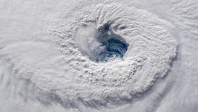


Hurricane Florence is undoubtedly a life-threatening, perhaps unprecedented colossus. As spotted by Earther’s Brian Kahn, a visualization of the predicted storm surge by The Weather Channel really hammers home just how lethal Florence could be.
Aside from its inherent terror, this video also nicely demonstrates that wind speed is a pretty poor way of measuring the damage potential of a hurricane.
The Saffir-Simpson Hurricane Wind Scale (SSHWS), developed in 1971 by a civil engineer and a meteorologist at the National Hurricane Center (NHC), relies on putting hurricanes in various categories – 1 to 5 – based on wind speed. This wasn’t always the case: storm surges and the central peak pressure were used until 2010, when the scale was simplified.
Wind speed is a proxy for the energy of a hurricane, sure, but most of the energy used by hurricanes isn’t in wind formation.
The “average” hurricane unleashes around 603 trillion joules every single second, but the amount that’s released through cloud and rain formation is 400 times that involved in kinetic energy-driven wind production. Sure, strong winds can cause damage and steal lives, but it’s the inundation that’s the major problem here.
The reason Hurricane Harvey was so dangerous wasn’t really related to its category, but the fact that it dumped a lot of rainfall in one place. Its water capacity, plus the fact that it stalled over Houston, were key.
That’s why reports that Hurricane Florence has weakened are perhaps misleading. It may be losing energetic steam, but it’s still a monster that'll cause plenty of flooding.
Flooding doesn’t just come from rainfall, of course. That’s where the beautifully rendered storm surge comes in, which is normally the deadliest part of a hurricane.
Hurricanes are low-pressure beasts, so when they move over shallow water, it rises a little in response. At the same time, the force of the winds pushes plenty of water towards the shore, where it piles up.
The final height of the storm surge depends on plenty of factors, including not just hurricane intensity, but the angle and speed of approach and the topography and permeability of land it’s encroaching on. This particular visualization, as with any storm surge estimates, takes all of this into account.
In fact, this video is a solid reminder that meteorologists are doing a consistently stellar job at getting the best information across to the public. This makes a difference to the choices people make, and influences whether people live or die, when hurricanes hit. Thorough climate reporting, like that of Kahn’s, also deserves a shout out.
Climatologists play a vital role too. They have the painstaking, difficult task of working out how human-driven warming will alter hurricanes' behaviors.
It’s pretty darn clear that, thanks to the thermal expansion of the oceans and the dumping of landlocked ice into them, sea levels are rising – and with them, storm surges. This factor has had a direct effect on that stunning, terrifying simulation of Hurricane Florence’s floodwaters. Incidentally, warmer air packets also permit them to produce more rain, which certainly isn’t helping matters.
Other variables, like increased hurricane frequency, are less certain, and attributing individual events’ severity to climate change is a work-in-progress. Nevertheless, for the first time, researchers have predicted the impact of climate change before the hurricane has terminated.
They suspect Florence will be larger and wetter than it otherwise would be. Only time will tell how on the money their calculations were, but the point remains the same: scientists of all kinds are doing their utmost to comprehend these increasingly unnatural hazards.
Bravo to all involved, and good luck to all those on the ground.


